

Florian Felberbauer
Games with Purpose - Improving 3D Model and Land Cover Data using Crowdsourcing
[ poster] [
 thesis]
Information
- Publication Type: Master Thesis
- Workgroup(s)/Project(s):
- Date: November 2012
- Date (Start): 30. March 2012
- Date (End): 30. September 2012
- TU Wien Library:
- First Supervisor:
- Keywords: social games, games with purpose

Abstract
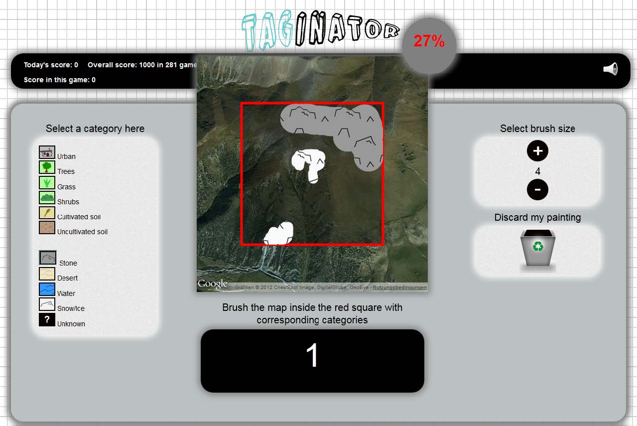
A variety of 3D-model databases are available on the internet, but the process of finding the right models is often tiring. This is because the majority of the available models is barely annotated or the quality is low. Annotations often are ambiguous, vague or too specialized. Besides 3Dmodel annotations, remote sensing data can be ambiguous too. Global land cover maps like GlobCover, MODIS and GLC2000 show large differences in certain areas of the world. This lack of correct data is a problem, because it is a basic requirement for a variety of research areas and applications.Consequently, this thesis aims at tackling both aforementioned problems. The task of recognizing and classifying images as well as 3D-models is easy to solve for human beings, but even today rather hard for computer systems. For that reason, this thesis makes use of the concepts of crowdsourcing. The quality of user annotations can be improved by collecting annotations from a variety of users and extract those with the highest frequency. To achieve this, a game has been implemented that unifies crowdsourcing and social games mechanics. This game consists of game-rounds which lead the user through the process of annotating 3D-models as well as land cover data. Also, a drawing round has been implemented to enable the user to classify a given land cover area using a pre-defined set of categories. As crowdsourcing is related to a large number of users, the focus is on implementing a game that provides incentives for users to spend their free time on playing, while solving useful tasks. To reach as many users as possible, the game has been implemented using only HTML5 and JavaScript to circumvent limitations due to missing plugins or external players and to support all systems, including mobile devices. It is also integrated into Facebook to further enlarge the number of reachable users.
The potential of the approach is demonstrated on the basis of a user study. The results show that the annotations with the highest frequency are good descriptors for the underlying 3D-models as well as for the land cover maps. None of the top annotations are incorrect for any model or map. Analyzing the user paintings also shows very good results. The majority of maps were classified correctly and even the distribution of categories over the maps are correct to a high degree. We thus show, that the combination of crowdsourcing and social games can improve land cover data and 3D-model annotations. These insights contribute to the ongoing Landspotting project, which is further explained in this thesis.
Additional Files and Images


Weblinks
No further information available.BibTeX
@mastersthesis{Felberbauer_2012_AG,
  title =      "Games with Purpose - Improving 3D Model and Land Cover Data
               using Crowdsourcing",
  author =     "Florian Felberbauer",
  year =       "2012",
  abstract =   "A variety of 3D-model databases are available on the
               internet, but the process of finding the right models is
               often tiring. This is because the majority of the available
               models is barely annotated or the quality is low.
               Annotations often are ambiguous, vague or too specialized.
               Besides 3Dmodel annotations, remote sensing data can be
               ambiguous too. Global land cover maps like GlobCover, MODIS
               and GLC2000 show large differences in certain areas of the
               world. This lack of correct data is a problem, because it is
               a basic requirement for a variety of research areas and
               applications.  Consequently, this thesis aims at tackling
               both aforementioned problems. The task of recognizing and
               classifying images as well as 3D-models is easy to solve for
               human beings, but even today rather hard for computer
               systems. For that reason, this thesis makes use of the
               concepts of crowdsourcing. The quality of user annotations
               can be improved by collecting annotations from a variety of
               users and extract those with the highest frequency. To
               achieve this, a game has been implemented that unifies
               crowdsourcing and social games mechanics. This game consists
               of game-rounds which lead the user through the process of
               annotating 3D-models as well as land cover data. Also, a
               drawing round has been implemented to enable the user to
               classify a given land cover area using a pre-defined set of
               categories. As crowdsourcing is related to a large number of
               users, the focus is on implementing a game that provides
               incentives for users to spend their free time on playing,
               while solving useful tasks. To reach as many users as
               possible, the game has been implemented using only HTML5 and
               JavaScript to circumvent limitations due to missing plugins
               or external players and to support all systems, including
               mobile devices. It is also integrated into Facebook to
               further enlarge the number of reachable users.  The
               potential of the approach is demonstrated on the basis of a
               user study. The results show that the annotations with the
               highest frequency are good descriptors for the underlying
               3D-models as well as for the land cover maps. None of the
               top annotations are incorrect for any model or map.
               Analyzing the user paintings also shows very good results.
               The majority of maps were classified correctly and even the
               distribution of categories over the maps are correct to a
               high degree. We thus show, that the combination of
               crowdsourcing and social games can improve land cover data
               and 3D-model annotations. These insights contribute to the
               ongoing Landspotting project, which is further explained in
               this thesis.",
  month =      nov,
  address =    "Favoritenstrasse 9-11/E193-02, A-1040 Vienna, Austria",
  school =     "Institute of Computer Graphics and Algorithms, Vienna
               University of Technology ",
  keywords =   "social games, games with purpose",
  URL =        "https://www.cg.tuwien.ac.at/research/publications/2012/Felberbauer_2012_AG/",
}