

Philipp Erler , Lukas Herzberger, Michael Wimmer, Markus Schütz
LidarScout: Direct Out-of-Core Rendering of Massive Point Clouds
In High-Performance Graphics 2025 - Symposium Papers. June 2025.
[ Paper] [
 video] [
![]() Viewer] [Repository of Viewer Source] [Repository of Training Source] [Presentation from HPG 2025]
Viewer] [Repository of Viewer Source] [Repository of Training Source] [Presentation from HPG 2025]
Information
- Publication Type: Conference Paper
- Workgroup(s)/Project(s):
- Date: June 2025
- ISBN: 978-3-03868-291-2
- Publisher: the Eurographics Association
- Location: Koppenhagen
- Lecturer: Philipp Erler
- Event: High-Performance Graphics 2025
- DOI: 10.2312/hpg.20251170
- Booktitle: High-Performance Graphics 2025 - Symposium Papers
- Article Number: 10.2312/hpg.20251170
- Pages: 11
- Conference date: 23. June 2025 – 25. June 2025
- Keywords: Point-based models, Mesh models, Neural networks, Reconstruction, Aerial LIDAR
Abstract
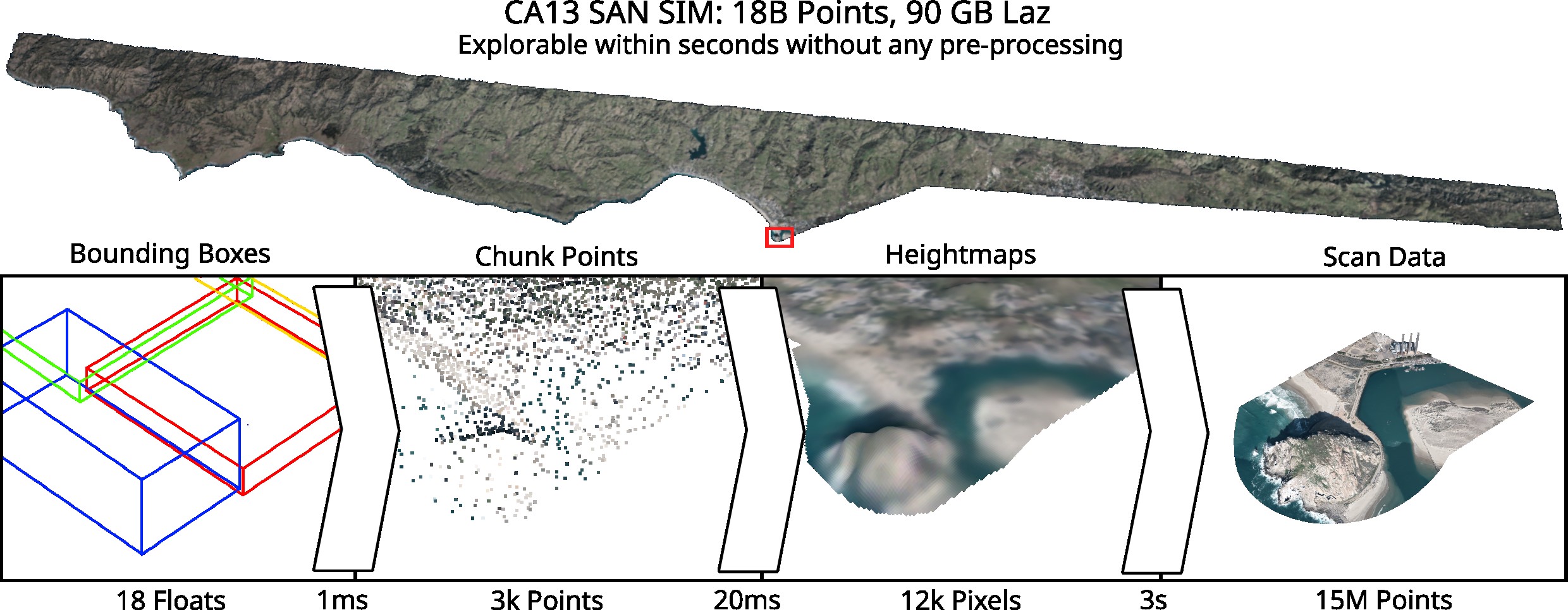
Large-scale terrain scans are the basis for many important tasks, such as topographic mapping, forestry, agriculture, and infrastructure planning. The resulting point cloud data sets are so massive in size that even basic tasks like viewing take hours to days of pre-processing in order to create level-of-detail structures that allow inspecting the data set in their entirety in real time. In this paper, we propose a method that is capable of instantly visualizing massive country-sized scans with hundreds of billions of points. Upon opening the data set, we first load a sparse subsample of points and initialize an overview of the entire point cloud, immediately followed by a surface reconstruction process to generate higher-quality, hole-free heightmaps. As users start navigating towards a region of interest, we continue to prioritize the heightmap construction process to the user's viewpoint. Once a user zooms in closely, we load the full-resolution point cloud data for that region and update the corresponding height map textures with the full-resolution data. As users navigate elsewhere, full-resolution point data that is no longer needed is unloaded, but the updated heightmap textures are retained as a form of medium level of detail. Overall, our method constitutes a form of direct out-of-core rendering for massive point cloud data sets (terabytes, compressed) that requires no preprocessing and no additional disk space. Source code, executable, pre-trained model, and dataset are available at: https://github.com/cg-tuwien/lidarscoutAdditional Files and Images
Additional images and videos
 video:
A screen capture of the viewer
video:
A screen capture of the viewer

Additional files

Weblinks
- Repository of Viewer Source
- Repository of Training Source
- Presentation from HPG 2025
- TUW Research Data Repository
Datasets, models, more results - Entry in reposiTUm (TU Wien Publication Database)
- DOI: 10.2312/hpg.20251170
BibTeX
@inproceedings{erler-2025-lidarscout,
  title =      "LidarScout: Direct Out-of-Core Rendering of Massive Point
               Clouds",
  author =     "Philipp Erler and Lukas Herzberger and Michael Wimmer and
               Markus Sch\"{u}tz",
  year =       "2025",
  abstract =   "Large-scale terrain scans are the basis for many important
               tasks, such as topographic mapping, forestry, agriculture,
               and infrastructure planning. The resulting point cloud data
               sets are so massive in size that even basic tasks like
               viewing take hours to days of pre-processing in order to
               create level-of-detail structures that allow inspecting the
               data set in their entirety in real time. In this paper, we
               propose a method that is capable of instantly visualizing
               massive country-sized scans with hundreds of billions of
               points. Upon opening the data set, we first load a sparse
               subsample of points and initialize an overview of the entire
               point cloud, immediately followed by a surface
               reconstruction process to generate higher-quality, hole-free
               heightmaps. As users start navigating towards a region of
               interest, we continue to prioritize the heightmap
               construction process to the user's viewpoint. Once a user
               zooms in closely, we load the full-resolution point cloud
               data for that region and update the corresponding height map
               textures with the full-resolution data. As users navigate
               elsewhere, full-resolution point data that is no longer
               needed is unloaded, but the updated heightmap textures are
               retained as a form of medium level of detail. Overall, our
               method constitutes a form of direct out-of-core rendering
               for massive point cloud data sets (terabytes, compressed)
               that requires no preprocessing and no additional disk space.
               Source code, executable, pre-trained model, and dataset are
               available at: https://github.com/cg-tuwien/lidarscout",
  month =      jun,
  isbn =       "978-3-03868-291-2",
  publisher =  "the Eurographics Association",
  location =   "Koppenhagen",
  event =      "High-Performance Graphics 2025",
  doi =        "10.2312/hpg.20251170",
  booktitle =  "High-Performance Graphics 2025 - Symposium Papers",
  articleno =  "10.2312/hpg.20251170",
  pages =      "11",
  keywords =   "Point-based models, Mesh models, Neural networks,
               Reconstruction, Aerial LIDAR",
  URL =        "https://www.cg.tuwien.ac.at/research/publications/2025/erler-2025-lidarscout/",
}