

Ahmed El Agrod
Immersive Redesign
[ thesis]
Information
- Publication Type: Bachelor Thesis
- Workgroup(s)/Project(s):
- Date: September 2022
- Date (Start): 15. January 2022
- Date (End): 5. September 2022
- Matrikelnummer: 11811340
- First Supervisor:
- Keywords: point clouds, object detection, editing

Abstract
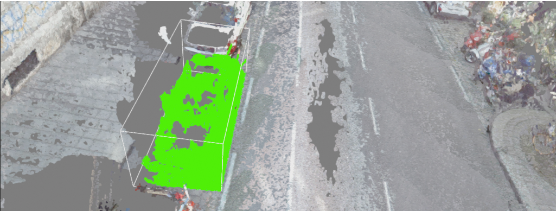
With scanning technologies and the processing power of computers increasing it is getting easier to scan the surrounding area and upload a 3D model of it. Nowadays mobile phones and drones are capable of doing that. However, the results most likely are not as good as dedicated scanners. To offer people an option to explore their scanned objects my colleague Manuel Keilman and I wrote a software with which users can upload multiple point clouds. Those point clouds can then be modified by adding, deleting, or moving parts of it. Our primary target is point clouds of street scenes. We selected an existing classification algorithm called GraND-Net [13] to identify objects of the scene. Since the classification algorithm does not cluster the classes a separate algorithm for that was needed. That is why we use DBScan [15] in order to distinguish different objects of the same class. Both steps are done before starting the application since they only have to be done once. The benefit of grouping points with similar features is that users do not have to manually select everything which improves the usability of our software. After classifying as well as clustering users can upload their point clouds and then select objects in order to modify them. Mistakes tend to happen which is why our software also offers users the option to manually classify whatever they want. All of that should make it easier for users to analyze and modify their point clouds.Additional Files and Images

Weblinks
No further information available.BibTeX
@bachelorsthesis{elagrod_ahmed-baa,
  title =      "Immersive Redesign",
  author =     "Ahmed El Agrod",
  year =       "2022",
  abstract =   "With scanning technologies and the processing power of
               computers increasing it is getting easier to scan the
               surrounding area and upload a 3D model of it. Nowadays
               mobile phones and drones are capable of doing that. However,
               the results most likely are not as good as dedicated
               scanners. To offer people an option to explore their scanned
               objects my colleague Manuel Keilman and I wrote a software
               with which users can upload multiple point clouds. Those
               point clouds can then be modified by adding, deleting, or
               moving parts of it. Our primary target is point clouds of
               street scenes. We selected an existing classification
               algorithm called GraND-Net [13] to identify objects of the
               scene. Since the classification algorithm does not cluster
               the classes a separate algorithm for that was needed. That
               is why we use DBScan [15] in order to distinguish different
               objects of the same class. Both steps are done before
               starting the application since they only have to be done
               once. The benefit of grouping points with similar features
               is that users do not have to manually select everything
               which improves the usability of our software. After
               classifying as well as clustering users can upload their
               point clouds and then select objects in order to modify
               them. Mistakes tend to happen which is why our software also
               offers users the option to manually classify whatever they
               want. All of that should make it easier for users to analyze
               and modify their point clouds.",
  month =      sep,
  address =    "Favoritenstrasse 9-11/E193-02, A-1040 Vienna, Austria",
  school =     "Research Unit of Computer Graphics, Institute of Visual
               Computing and Human-Centered Technology, Faculty of
               Informatics, TU Wien ",
  keywords =   "point clouds, object detection, editing",
  URL =        "https://www.cg.tuwien.ac.at/research/publications/2022/elagrod_ahmed-baa/",
}