

Peter Houska
Improved Persistent Grid Mapping
[ poster] [
 thesis]
Information
- Publication Type: Master Thesis
- Workgroup(s)/Project(s):
- Date: February 2020
- Date (Start): 1. January 2009
- Date (End): 7. February 2020
- TU Wien Library:
- Diploma Examination: 7. February 2020
- Open Access: yes
- First Supervisor:

Abstract
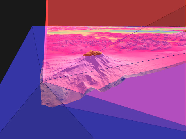
We propose a novel heightmap-based terrain rendering algorithm that enhances the Persistent Grid Mapping (PGM) method. As in the underlying method, we cache a regular triangulated grid in video memory and use the GPU to project the mesh onto the ground plane each frame anew. Each vertex in the grid is then displaced according to the sampled heightmap value along the ground plane’s normal vector. The perspective mapping of the grid results in a view-dependent, continuous level-of-detail approximation of the terrain dataset.PGM is a simple and elegant terrain rendering algorithm, however, as the camera hovers over the terrain, projected vertex positions slide over the terrain. This leads to the underlying static terrain surface changing shape slightly from frame to frame. We address these swimming artifacts by introducing four improvements: tailoring the projected grid, which pushes most otherwise culled vertices back into the view frustum, redistributing grid vertices according to an importance function for more faithful mipmap selection when sampling the heightmap, local terrain edge search for vertices within a certain proximity to the camera, and exploiting temporal coherence between frames. While our algorithm cannot guarantee a maximum screen-space error, it nevertheless reduces PGM’s inherent temporal aliasing artifacts considerably.
Additional Files and Images


Weblinks
No further information available.BibTeX
@mastersthesis{houska-2020-IPGM,
  title =      "Improved Persistent Grid Mapping",
  author =     "Peter Houska",
  year =       "2020",
  abstract =   "We propose a novel heightmap-based terrain rendering
               algorithm that enhances the Persistent Grid Mapping (PGM)
               method. As in the underlying method, we cache a regular
               triangulated grid in video memory and use the GPU to project
               the mesh onto the ground plane each frame anew. Each vertex
               in the grid is then displaced according to the sampled
               heightmap value along the ground plane’s normal vector.
               The perspective mapping of the grid results in a
               view-dependent, continuous level-of-detail approximation of
               the terrain dataset.  PGM is a simple and elegant terrain
               rendering algorithm, however, as the camera hovers over the
               terrain, projected vertex positions slide over the terrain.
               This leads to the underlying static terrain surface changing
               shape slightly from frame to frame. We address these
               swimming artifacts by introducing four improvements:
               tailoring the projected grid, which pushes most otherwise
               culled vertices back into the view frustum, redistributing
               grid vertices according to an importance function for more
               faithful mipmap selection when sampling the heightmap, local
               terrain edge search for vertices within a certain proximity
               to the camera, and exploiting temporal coherence between
               frames. While our algorithm cannot guarantee a maximum
               screen-space error, it nevertheless reduces PGM’s inherent
               temporal aliasing artifacts considerably.",
  month =      feb,
  address =    "Favoritenstrasse 9-11/E193-02, A-1040 Vienna, Austria",
  school =     "Research Unit of Computer Graphics, Institute of Visual
               Computing and Human-Centered Technology, Faculty of
               Informatics, TU Wien",
  URL =        "https://www.cg.tuwien.ac.at/research/publications/2020/houska-2020-IPGM/",
}