

Shigeo Takahashi, Ken Maruyama, Takamasa Kawagoe, Hsiang-Yun Wu , Kazuo Misue, Masatoshi Arikawa
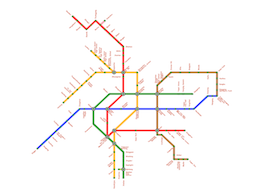
Mental Map Preservation for Progressively Labeling Railway Networks
International Journal of Art, Culture and Design Technologies, 8(1):31-50, June 2019. [ pdf]
pdf]
Information
- Publication Type: Journal Paper (without talk)
- Workgroup(s)/Project(s):
- Date: June 2019
- DOI: https://doi.org/10.4018/IJACDT.2019010103
- Journal: International Journal of Art, Culture and Design Technologies
- Number: 1
- Volume: 8
- Pages: 31 – 50
- Keywords: Geodesic Distances, Mental Maps, Mixed-Integer Programming, Progressive Annotation, Railway Maps, Schematic Layouts
Abstract
Schematizing railway networks for better readability is often achieved by aligning railway lines along the octilinear directions. However, such railway map layouts require further adjustment when placing station name labels. In this article, the authors present a novel approach to automating the placement of station names around the railway network while maximally respecting its original layout as the mental map. The key idea is to progressively annotate stations from congested central downtown areas to sparse rural areas. This is accomplished by introducing the sum of geodesic distances over the railway network to properly order the stations to be annotated first, and then elongating the line segments of the railway network while retaining their directions to spare enough labeling space around each station. Additional constraints are also introduced to restrict the aspect ratios of the region confined by the railway network for better preservation of the mental map.Additional Files and Images

Weblinks
BibTeX
@article{takahashi-2019-acdt,
  title =      "Mental Map Preservation for Progressively Labeling Railway
               Networks",
  author =     "Shigeo Takahashi and Ken Maruyama and Takamasa  Kawagoe and
               Hsiang-Yun Wu and Kazuo Misue and Masatoshi  Arikawa",
  year =       "2019",
  abstract =   "Schematizing railway networks for better readability is
               often achieved by aligning railway lines along the
               octilinear directions. However, such railway map layouts
               require further adjustment when placing station name labels.
               In this article, the authors present a novel approach to
               automating the placement of station names around the railway
               network while maximally respecting its original layout as
               the mental map. The key idea is to progressively annotate
               stations from congested central downtown areas to sparse
               rural areas. This is accomplished by introducing the sum of
               geodesic distances over the railway network to properly
               order the stations to be annotated first, and then
               elongating the line segments of the railway network while
               retaining their directions to spare enough labeling space
               around each station. Additional constraints are also
               introduced to restrict the aspect ratios of the region
               confined by the railway network for better preservation of
               the mental map.",
  month =      jun,
  doi =        "https://doi.org/10.4018/IJACDT.2019010103",
  journal =    "International Journal of Art, Culture and Design
               Technologies",
  number =     "1",
  volume =     "8",
  pages =      "31--50",
  keywords =   "Geodesic Distances, Mental Maps, Mixed-Integer Programming,
               Progressive Annotation, Railway Maps, Schematic Layouts",
  URL =        "https://www.cg.tuwien.ac.at/research/publications/2019/takahashi-2019-acdt/",
}