

Klemens Wiesinger
Using a drone for automated 3D Scanning
[ thesis]
Information
- Publication Type: Bachelor Thesis
- Workgroup(s)/Project(s):
- Date: March 2025
- Date (Start): 13. July 2023
- Date (End): 28. March 2025
- Matrikelnummer: 11938253
- First Supervisor:
- Keywords: drone, scanning, automation

Abstract
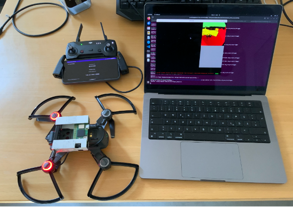
Drones have been widely adopted over the past decades, aiding in critical tasks such as search and rescue, inspection, and mapping. Autonomous drone scanning could further support such missions, but remains a significant challenge in indoor environments. This thesis explores the feasibility of using a consumer drone for such autonomous indoor 3D scanning. Our approach combines a DJI Spark drone, a lightweight Pico Flexx depth sensor, and a Raspberry Pi to capture depth data, which is streamed to an external server for real-time processing. The system leverages ROS 2 and InfiniTAM for SLAM and map reconstruction, while navigation commands are issued via a smartphone using DJI’s Mobile SDK. Although the system successfully completed a limited autonomous scan, various con- straints—including the drone’s payload capacity, limited sensor range, and hardware instabilities—posed significant challenges. Despite these limitations, a modular software architecture was developed that integrates sensing, mapping, and navigation. This framework provides a solid foundation for future work toward fully autonomous indoor scanning with more capable hardware. However, generating the next best view and finding a feasible path toward it remain open challenges.Additional Files and Images

Weblinks
No further information available.BibTeX
@bachelorsthesis{wiesinger_2025-baa,
  title =      "Using a drone for automated 3D Scanning",
  author =     "Klemens Wiesinger",
  year =       "2025",
  abstract =   "Drones have been widely adopted over the past decades,
               aiding in critical tasks such as search and rescue,
               inspection, and mapping. Autonomous drone scanning could
               further support such missions, but remains a significant
               challenge in indoor environments. This thesis explores the
               feasibility of using a consumer drone for such autonomous
               indoor 3D scanning. Our approach combines a DJI Spark drone,
               a lightweight Pico Flexx depth sensor, and a Raspberry Pi to
               capture depth data, which is streamed to an external server
               for real-time processing. The system leverages ROS 2 and
               InfiniTAM for SLAM and map reconstruction, while navigation
               commands are issued via a smartphone using DJI’s Mobile
               SDK. Although the system successfully completed a limited
               autonomous scan, various con- straints—including the
               drone’s payload capacity, limited sensor range, and
               hardware instabilities—posed significant challenges.
               Despite these limitations, a modular software architecture
               was developed that integrates sensing, mapping, and
               navigation. This framework provides a solid foundation for
               future work toward fully autonomous indoor scanning with
               more capable hardware. However, generating the next best
               view and finding a feasible path toward it remain open
               challenges.",
  month =      mar,
  address =    "Favoritenstrasse 9-11/E193-02, A-1040 Vienna, Austria",
  school =     "Research Unit of Computer Graphics, Institute of Visual
               Computing and Human-Centered Technology, Faculty of
               Informatics, TU Wien ",
  keywords =   "drone, scanning, automation",
  URL =        "https://www.cg.tuwien.ac.at/research/publications/2025/wiesinger_2025-baa/",
}