

Kevin Streicher
Digital Surveying of Large Scale Multi-Layered Terrain
[ Master thesis] [
 poster]
Information
- Publication Type: Master Thesis
- Workgroup(s)/Project(s):
- Date: 2022
- Date (Start): 16. July 2016
- Date (End): 11. October 2022
- TU Wien Library:
- Second Supervisor: Christoph Traxler

- Diploma Examination: 11. October 2022
- Open Access: yes
- First Supervisor: Michael Wimmer
- Pages: 112
- Keywords: out-of-core, digital terrain surveying, large-scale terrain streaming, uncertainty
Abstract
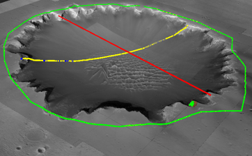
Digital terrain surveying is the exploration of terrain reconstructions and quantitative analysis of their properties. Out-of-core techniques, such as terrain streaming, are required to perform surveying on large-scale terrains at interactive frame-rates.The polyline based surveying tool from PRo3D, one of the state-of-the-art solutions for planetary geology, was implemented in our tool Visionary. In PRo3D the polylines are subsampled using fixed-rate subsampling (FRSS) at equidistant points. Our method uses variable-rate subsampling (VRSS) and shared-edge detection (SED) as an improvement that finds exact results when neighbouring primitives are hit. Furthermore, an uncertainty metric On-Data Ratio (ODR) was presented to raise awareness about the uncertainty of these measurements. Visionary was developed in the Unity game engine to evaluate if it is a suitable framework for such a specialized tool. We evaluated our implementation against Pro3D.Additional Files and Images


Weblinks
BibTeX
@mastersthesis{STREICHER-2022-DSLS,
  title =      "Digital Surveying of Large Scale Multi-Layered Terrain",
  author =     "Kevin Streicher",
  year =       "2022",
  abstract =   "Digital terrain surveying is the exploration of terrain
               reconstructions and quantitative analysis of their
               properties. Out-of-core techniques, such as terrain
               streaming, are required to perform surveying on large-scale
               terrains at interactive frame-rates.The polyline based
               surveying tool from PRo3D, one of the state-of-the-art
               solutions for planetary geology, was implemented in our tool
               Visionary. In PRo3D the polylines are subsampled using
               fixed-rate subsampling (FRSS) at equidistant points. Our
               method uses variable-rate subsampling (VRSS) and shared-edge
               detection (SED) as an improvement that finds exact results
               when neighbouring primitives are hit. Furthermore, an
               uncertainty metric On-Data Ratio (ODR) was presented to
               raise awareness about the uncertainty of these measurements.
               Visionary was developed in the Unity game engine to evaluate
               if it is a suitable framework for such a specialized tool.
               We evaluated our implementation against Pro3D.",
  pages =      "112",
  address =    "Favoritenstrasse 9-11/E193-02, A-1040 Vienna, Austria",
  school =     "Research Unit of Computer Graphics, Institute of Visual
               Computing and Human-Centered Technology, Faculty of
               Informatics, TU Wien",
  keywords =   "out-of-core, digital terrain surveying, large-scale terrain
               streaming, uncertainty",
  URL =        "https://www.cg.tuwien.ac.at/research/publications/2022/STREICHER-2022-DSLS/",
}