

Daniel Cornel
Interactive Visualization of Simulation Data for GeospatialDecision Support
Supervisor: Eduard Gröller
[image] [ PhD Thesis]
Information
- Publication Type: PhD-Thesis
- Workgroup(s)/Project(s):
- Date: January 2020
- TU Wien Library:
- Open Access: yes
- 1st Reviewer: Natalie Andrienko
- 2nd Reviewer: Elmar Eisemann
- Rigorosum: January 2020
- First Supervisor: Eduard Gröller
- Pages: 167
- Keywords: Interactive visualization, uncertainty, flood management, decision support, flood simulation
Abstract
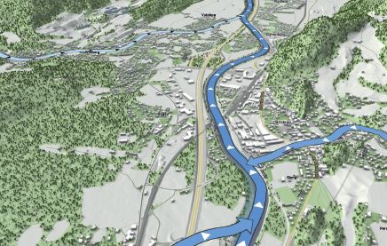
Floods are catastrophic events that claim thousands of human lives every year. For theprediction of these events, interactive decision support systems with integrated floodsimulation have become a vital tool. Recent technological advances made it possibleto simulate flooding scenarios of unprecedented scale and resolution, resulting in verylarge time-dependent data. The amount of simulation data is further amplified by theuse of ensemble simulations to make predictions more robust, yielding high-dimensionaland uncertain data far too large for manual exploration. New strategies are thereforeneeded to filter these data and to display only the most important information to supportdomain experts in their daily work. This includes the communication of results to decisionmakers, emergency services, stakeholders, and the general public. A modern decisionsupport system has to be able to provide visual results that are useful for domain experts,but also comprehensible for larger audiences. Furthermore, for an efficient workflow, theentire process of simulation, analysis, and visualization has to happen in an interactivefashion, putting serious time constraints on the system.In this thesis, we present novel visualization techniques for time-dependent and uncertainflood, logistics, and pedestrian simulation data for an interactive decision support system.As the heterogeneous tasks in flood management require very diverse visualizations fordifferent target audiences, we provide solutions to key tasks in the form of task-specificand user-specific visualizations. This allows the user to show or hide detailed informationon demand to obtain comprehensible and aesthetic visualizations to support the task athand. In order to identify the impact of flooding incidents on a building of interest, onlya small subset of all available data is relevant, which is why we propose a solution toisolate this information from the massive simulation data. To communicate the inherentuncertainty of resulting predictions of damages and hazards, we introduce a consistentstyle for visualizing the uncertainty within the geospatial context. Instead of directlyshowing simulation data in a time-dependent manner, we propose the use of bidirectionalflow maps with multiple components as a simplified representation of arbitrary materialflows. For the communication of flood risks in a comprehensible way, however, thedirect visualization of simulation data over time can be desired. Apart from the obviouschallenges of the complex simulation data, the discrete nature of the data introducesadditional problems for the realistic visualization of water surfaces, for which we proposerobust solutions suitable for real-time applications. All of our findings have been acquiredthrough a continuous collaboration with domain experts from several flood-related fieldsof work. The thorough evaluation of our work by these experts confirms the relevanceand usefulness of our presented solutions.Additional Files and Images

Weblinks
BibTeX
@phdthesis{Cornel_2020,
  title =      "Interactive Visualization of Simulation Data for
               GeospatialDecision Support",
  author =     "Daniel Cornel",
  year =       "2020",
  abstract =   "Floods are catastrophic events that claim thousands of human
               lives every year. For theprediction of these events,
               interactive decision support systems with integrated
               floodsimulation have become a vital tool. Recent
               technological advances made it possibleto simulate flooding
               scenarios of unprecedented scale and resolution, resulting
               in verylarge time-dependent data. The amount of simulation
               data is further amplified by theuse of ensemble simulations
               to make predictions more robust, yielding
               high-dimensionaland uncertain data far too large for manual
               exploration. New strategies are thereforeneeded to filter
               these data and to display only the most important
               information to supportdomain experts in their daily work.
               This includes the communication of results to
               decisionmakers, emergency services, stakeholders, and the
               general public. A modern decisionsupport system has to be
               able to provide visual results that are useful for domain
               experts,but also comprehensible for larger audiences.
               Furthermore, for an efficient workflow, theentire process of
               simulation, analysis, and visualization has to happen in an
               interactivefashion, putting serious time constraints on the
               system.In this thesis, we present novel visualization
               techniques for time-dependent and uncertainflood, logistics,
               and pedestrian simulation data for an interactive decision
               support system.As the heterogeneous tasks in flood
               management require very diverse visualizations fordifferent
               target audiences, we provide solutions to key tasks in the
               form of task-specificand user-specific visualizations. This
               allows the user to show or hide detailed informationon
               demand to obtain comprehensible and aesthetic visualizations
               to support the task athand. In order to identify the impact
               of flooding incidents on a building of interest, onlya small
               subset of all available data is relevant, which is why we
               propose a solution toisolate this information from the
               massive simulation data. To communicate the
               inherentuncertainty of resulting predictions of damages and
               hazards, we introduce a consistentstyle for visualizing the
               uncertainty within the geospatial context. Instead of
               directlyshowing simulation data in a time-dependent manner,
               we propose the use of bidirectionalflow maps with multiple
               components as a simplified representation of arbitrary
               materialflows. For the communication of flood risks in a
               comprehensible way, however, thedirect visualization of
               simulation data over time can be desired. Apart from the
               obviouschallenges of the complex simulation data, the
               discrete nature of the data introducesadditional problems
               for the realistic visualization of water surfaces, for which
               we proposerobust solutions suitable for real-time
               applications. All of our findings have been acquiredthrough
               a continuous collaboration with domain experts from several
               flood-related fieldsof work. The thorough evaluation of our
               work by these experts confirms the relevanceand usefulness
               of our presented solutions.  ",
  month =      jan,
  pages =      "167",
  address =    "Favoritenstrasse 9-11/E193-02, A-1040 Vienna, Austria",
  school =     "Research Unit of Computer Graphics, Institute of Visual
               Computing and Human-Centered Technology, Faculty of
               Informatics, TU Wien ",
  keywords =   "Interactive visualization, uncertainty, flood management,
               decision support, flood simulation",
  URL =        "https://www.cg.tuwien.ac.at/research/publications/2020/Cornel_2020/",
}