

Claus Scheiblauer
Interactions with Gigantic Point Clouds
Supervisor: Michael Wimmer
Duration: December 2006 — July 2014
[ thesis]
Information
- Publication Type: PhD-Thesis
- Workgroup(s)/Project(s):
- Date: 2014
- Date (Start): December 2006
- Date (End): July 2014
- TU Wien Library:
- 1st Reviewer: Michael Wimmer
- 2nd Reviewer: Reinhard Klein
- Rigorosum: 18. July 2014
- First Supervisor: Michael Wimmer
- Keywords: point-based rendering, out-of-core rendering, data structures, complexity analysis
Abstract
During the last decade the increased use of laser range-scanners for sampling the environment has led to gigantic point cloud data sets. Due to the size of such data sets, tasks like viewing, editing, or presenting the data have become a challenge per se, as the point data is too large to fit completely into the main memory of a customary computer system. In order to accomplish these tasks and enable the interaction with gigantic point clouds on consumer grade computer systems, this thesis presents novel methods and data structures for efficiently dealing with point cloud data sets consisting of more than 109 point samples.To be able to access point samples fast that are stored on disk or in memory, they have to be spatially ordered, and for this a data structure is proposed which organizes the points samples in a level-of-detail hierarchy. Point samples stored in this hierarchy cannot only be rendered fast, but can also be edited, for example existing points can be deleted from the hierarchy or new points can be inserted. Furthermore, the data structure is memory efficient, as it only uses the point samples from the original data set. Therefore, the memory consumption of the point samples on disk, when stored in this data structure, is comparable to the original data set. A second data structure is proposed for selecting points. This data structure describes a volume inside which point samples are considered to be selected, and this has the advantage that the information about a selection does not have to be stored at the point samples.
In addition to these two previously mentioned data structures, which represent novel contributions for point data visualization and manipulation, methods for supporting the presentation of point data sets are proposed. With these methods the user experience can be enhanced when navigating through the data. One possibility to do this is by using regional meshes that employ an out-of-core texturing method to show details in the mesoscopic scale on the surface of sampled objects, and which are displayed together with point clouds. Another possibility to increase the user experience is to use graphs in 3D space, which helps users to orient themselves inside point cloud models of large sites, where otherwise it would be difficult to find the places of interest. Furthermore, the quality of the displayed point cloud models can be increased by using a point size heuristics that can mimic a closed surface in areas that would otherwise appear undersampled, by utilizing the density of the rendered points in the different areas of the point cloud model.
Finally, the use of point cloud models as a tool for archaeological work is proposed. Since it becomes increasingly common to document archaeologically interesting monuments with laser scanners, the number application areas of the resulting point clouds is raising as well. These include, but are not limited to, new views of the monument that are impossible when studying the monument on-site, creating cuts and floor plans, or perform virtual anastylosis.
All these previously mentioned methods and data structures are implemented in a single software application that has been developed during the course of this thesis and can be used to interactively explore gigantic point clouds.
Additional Files and Images
Additional images and videos
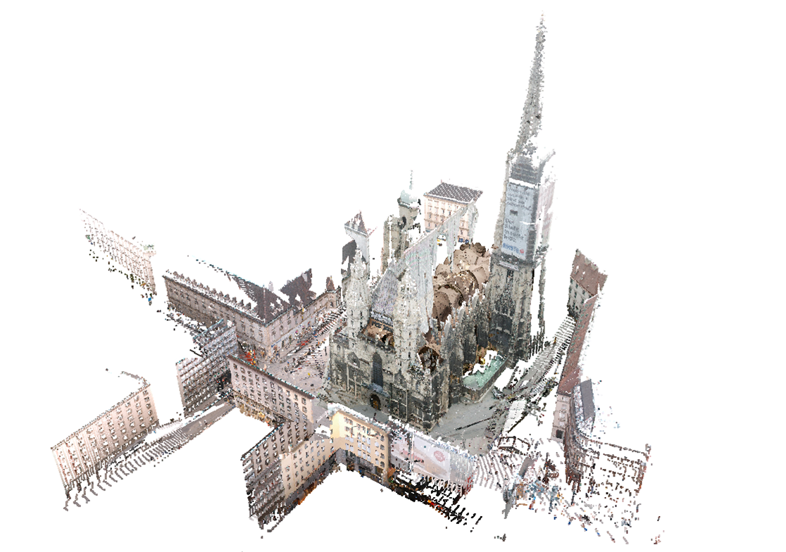
image:
Point model of the Wiener Stephansdom consisting of 460 million points
Additional files

Weblinks
No further information available.BibTeX
@phdthesis{scheiblauer-thesis,
  title =      "Interactions with Gigantic Point Clouds",
  author =     "Claus Scheiblauer",
  year =       "2014",
  abstract =   "During the last decade the increased use of laser
               range-scanners for sampling the environment has led to
               gigantic point cloud data sets. Due to the size of such data
               sets, tasks like viewing, editing, or presenting the data
               have become a challenge per se, as the point data is too
               large to fit completely into the main memory of a customary
               computer system. In order to accomplish these tasks and
               enable the interaction with gigantic point clouds on
               consumer grade computer systems, this thesis presents novel
               methods and data structures for efficiently dealing with
               point cloud data sets consisting of more than 109 point
               samples.   To be able to access point samples fast that are
               stored on disk or in memory, they have to be spatially
               ordered, and for this a data structure is proposed which
               organizes the points samples in a level-of-detail hierarchy.
               Point samples stored in this hierarchy cannot only be
               rendered fast, but can also be edited, for example existing
               points can be deleted from the hierarchy or new points can
               be inserted. Furthermore, the data structure is memory
               efficient, as it only uses the point samples from the
               original data set. Therefore, the memory consumption of the
               point samples on disk, when stored in this data structure,
               is comparable to the original data set. A second data
               structure is proposed for selecting points. This data
               structure describes a volume inside which point samples are
               considered to be selected, and this has the advantage that
               the information about a selection does not have to be stored
               at the point samples.   In addition to these two previously
               mentioned data structures, which represent novel
               contributions for point data visualization and manipulation,
               methods for supporting the presentation of point data sets
               are proposed. With these methods the user experience can be
               enhanced when navigating through the data. One possibility
               to do this is by using regional meshes that employ an
               out-of-core texturing method to show details in the
               mesoscopic scale on the surface of sampled objects, and
               which are displayed together with point clouds. Another
               possibility to increase the user experience is to use graphs
               in 3D space, which helps users to orient themselves inside
               point cloud models of large sites, where otherwise it would
               be difficult to find the places of interest. Furthermore,
               the quality of the displayed point cloud models can be
               increased by using a point size heuristics that can mimic a
               closed surface in areas that would otherwise appear
               undersampled, by utilizing the density of the rendered
               points in the different areas of the point cloud model.
               Finally, the use of point cloud models as a tool for
               archaeological work is proposed. Since it becomes
               increasingly common to document archaeologically interesting
               monuments with laser scanners, the number application areas
               of the resulting point clouds is raising as well. These
               include, but are not limited to, new views of the monument
               that are impossible when studying the monument on-site,
               creating cuts and floor plans, or perform virtual
               anastylosis.   All these previously mentioned methods and
               data structures are implemented in a single software
               application that has been developed during the course of
               this thesis and can be used to interactively explore
               gigantic point clouds.",
  address =    "Favoritenstrasse 9-11/E193-02, A-1040 Vienna, Austria",
  school =     "Institute of Computer Graphics and Algorithms, Vienna
               University of Technology ",
  keywords =   "point-based rendering, out-of-core rendering, data
               structures, complexity analysis",
  URL =        "https://www.cg.tuwien.ac.at/research/publications/2014/scheiblauer-thesis/",
}