

Irene Reisner-Kollmann, Christian Luksch, Michael Schwärzler
Reconstructing Buildings as Textured Low Poly Meshes from Point Clouds and Images
In Eurographics 2011 - Short Papers, pages 17-20. April 2011.
Information
- Publication Type: Conference Paper
- Workgroup(s)/Project(s):
- Date: April 2011
- Location: Llandudno, UK
- Lecturer: Irene Reisner-Kollmann
- Editor: Nick Avis and Sylvain Lefebvre
- Booktitle: Eurographics 2011 - Short Papers
- Pages: 17 – 20
- Keywords: Modeling packages, Computational Geometry and Object Modeli
Abstract
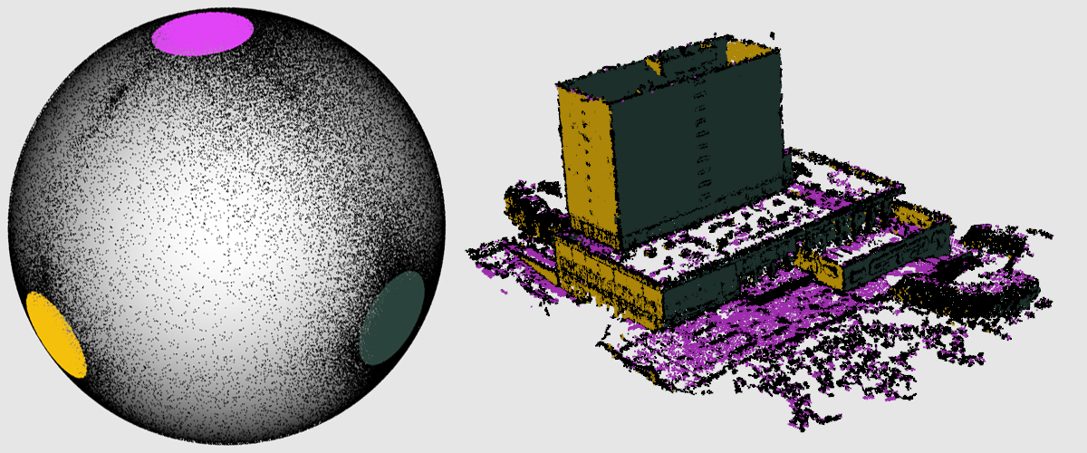
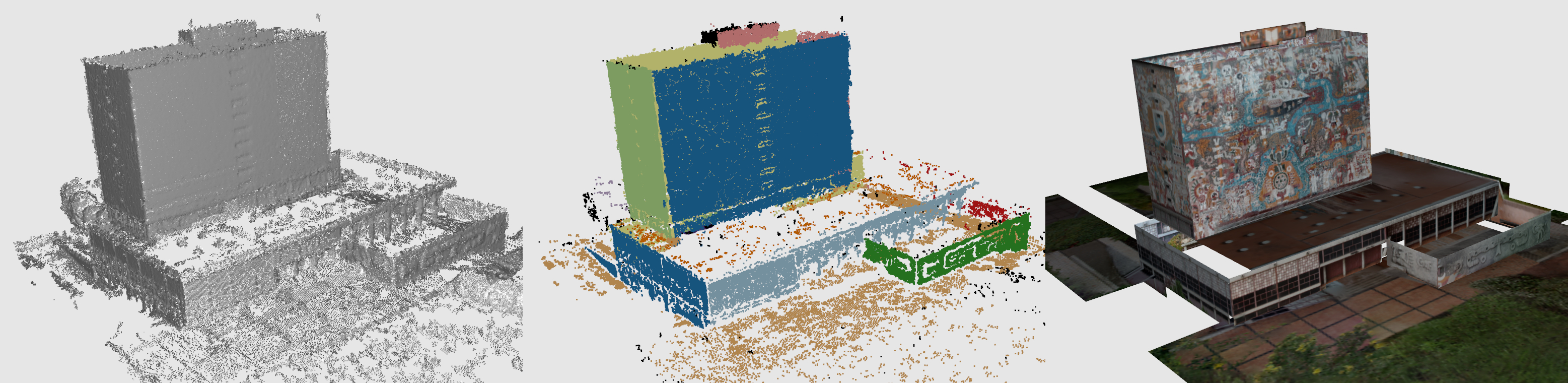
Current urban building reconstruction techniques rely mainly on data gathered from either laser scans or image- based approaches, and do usually require a large amount of manual post-processing and modeling. Difficulties arise due to erroneous and noisy data, and due to the huge amount of information to process. We propose a system that helps to overcome these time-consuming steps by automatically generating low-poly 3D building models. This is achieved by taking both information from point clouds and image information into account, exploiting the particular strengths and avoiding the relative weaknesses of these data sources: While the segmented point cloud is used to identify the dominant planar surfaces in 3D space, the images are used to extract accurate edges, fill holes and generate textured polygonal meshes of urban buildings.Additional Files and Images

Weblinks
No further information available.BibTeX
@inproceedings{reisner-2011-akgeo,
  title =      "Reconstructing Buildings as Textured Low Poly Meshes from
               Point Clouds and Images",
  author =     "Irene Reisner-Kollmann and Christian Luksch and Michael
               Schw\"{a}rzler",
  year =       "2011",
  abstract =   "Current urban building reconstruction techniques rely mainly
               on data gathered from either laser scans or image- based
               approaches, and do usually require a large amount of manual
               post-processing and modeling. Difficulties arise due to
               erroneous and noisy data, and due to the huge amount of
               information to process. We propose a system that helps to
               overcome these time-consuming steps by automatically
               generating low-poly 3D building models. This is achieved by
               taking both information from point clouds and image
               information into account, exploiting the particular
               strengths and avoiding the relative weaknesses of these data
               sources: While the segmented point cloud is used to identify
               the dominant planar surfaces in 3D space, the images are
               used to extract accurate edges, fill holes and generate
               textured polygonal meshes of urban buildings.",
  month =      apr,
  location =   "Llandudno, UK",
  editor =     "Nick Avis and Sylvain Lefebvre",
  booktitle =  "Eurographics 2011 - Short Papers",
  pages =      "17--20",
  keywords =   "Modeling packages, Computational Geometry and Object Modeli",
  URL =        "https://www.cg.tuwien.ac.at/research/publications/2011/reisner-2011-akgeo/",
}