

Pushpak Karnik, David Cline, Stefan Jeschke, Anshuman Razdan, Peter Wonka
Route Visualization using Detail Lenses
IEEE Transactions on Visualization and Computer Graphics, 16(2):235-247, 2009. [ paper]
Information
- Publication Type: Journal Paper (without talk)
- Workgroup(s)/Project(s): not specified
- Date: 2009
- ISSN: 1077-2626
- Journal: IEEE Transactions on Visualization and Computer Graphics
- Number: 2
- Volume: 16
- Pages: 235 – 247
Abstract
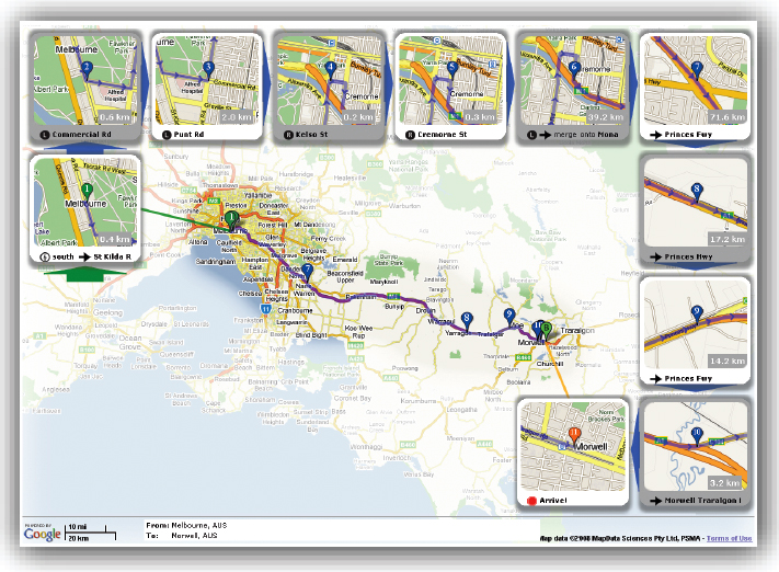
We present a method designed to address some limitations of typical route map displays of driving directions. The main goal of our system is to generate a printable version of a route map that shows the overview and detail views of the route within a single, consistent visual frame. Our proposed visualization provides a more intuitive spatial context than a simple list of turns. We present a novel multi-focus technique to achieve this goal, where the foci are defined by points-of-interest (POI) along the route. A detail lens that encapsulates the POI at a finer geospatial scale is created for each focus. The lenses are laid out on the map to avoid occlusion with the route and each other, and to optimally utilize the free space around the route. We define a set of layout metrics to evaluate the quality of a lens layout for a given route map visualization. We compare standard lens layout methods to our proposed method and demonstrate the effectiveness of our method in generating aesthetically pleasing layouts. Finally, we perform a user study to evaluate the effectiveness of our layout choices.Additional Files and Images
Additional images and videos
image:
Example for a route visualized with our system.
Additional files
 paper:
preprint
paper:
preprint
Weblinks
No further information available.BibTeX
@article{Karnik-2010-routevis,
  title =      "Route Visualization using Detail Lenses",
  author =     "Pushpak Karnik and David Cline and Stefan Jeschke and
               Anshuman Razdan and Peter Wonka",
  year =       "2009",
  abstract =   "We present a method designed to address some limitations of
               typical route map displays of driving directions. The main
               goal of our system is to generate a printable version of a
               route map that shows the overview and detail views of the
               route within a single, consistent visual frame. Our proposed
               visualization provides a more intuitive spatial context than
               a simple list of turns. We present a novel multi-focus
               technique to achieve this goal, where the foci are defined
               by points-of-interest (POI) along the route. A detail lens
               that encapsulates the POI at a finer geospatial scale is
               created for each focus. The lenses are laid out on the map
               to avoid occlusion with the route and each other, and to
               optimally utilize the free space around the route. We define
               a set of layout metrics to evaluate the quality of a lens
               layout for a given route map visualization. We compare
               standard lens layout methods to our proposed method and
               demonstrate the effectiveness of our method in generating
               aesthetically pleasing layouts. Finally, we perform a user
               study to evaluate the effectiveness of our layout choices.",
  issn =       "1077-2626",
  journal =    "IEEE Transactions on Visualization and Computer Graphics",
  number =     "2",
  volume =     "16",
  pages =      "235--247",
  URL =        "https://www.cg.tuwien.ac.at/research/publications/2009/Karnik-2010-routevis/",
}