

Information
- Publication Type: Bachelor Thesis
- Workgroup(s)/Project(s):
- Date: June 2026
- Date (Start): 1. January 2026
- Date (End): 25. June 2026
- Matrikelnummer: 12122563
- First Supervisor: Eduard Gröller

Abstract
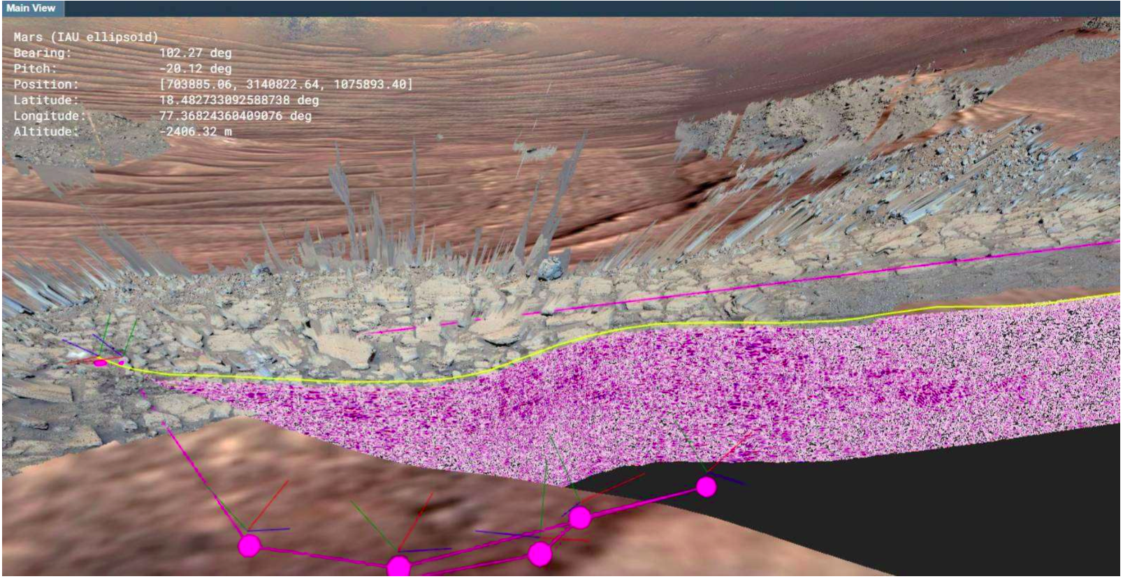
This thesis presents an interactive visualization approach for integrating subsurface radar data acquired by the Radar Imager for Mars’ Subsurface Experiment (RIMFAX) into a three-dimensional terrain context. RIMFAX radargrams represent subsurface reflections recorded along the Perseverance rover traverse and are therefore two-dimensional data embedded in three-dimensional space. To improve their spatial interpretability, this work investigates cross-sections that open the terrain along a selected path and display the corresponding radargram on a curtain-shaped surface.The developed prototype supports both interactively drawn paths and imported rover traverses. A central challenge is the consistent classification of the terrain for paths containing sharp turns, concave regions, loops, or selfintersections. Several local approaches were investigated, including tiled clipping planes and a nearest-point heuristic based on a frozen viewing direction. These methods produced inconsistent or visually unclear classifications for geometrically complex paths.
The final method reformulates the clipping problem as a two-dimensional point-in-polygon classification. The path is combined with an additional reference point to form a closed polygon, and terrain vertices are projected into a common two-dimensional coordinate system and classified as inside or outside this polygon. The classification is computed on the CPU and transferred to the GPU as a per-vertex attribute, where interpolation and fragment discarding produce the visible terrain cut. For fixed inputs, this approach provides stable and reproducible results and handles concave paths more consistently than the explored local methods.
A continuous curtain is generated along the complete cross-section path by expanding its line segments into vertical quads. Normalized arc-length texture coordinates provide a continuous horizontal parameterization and allow the radargram to be mapped according to distance along the path.
The implementation is written in F# using the Aardvark Platform and processes the terrain through its Out-of-Core Point Cloud (OPC) patch hierarchy. It therefore uses technologies, data structures, and rendering mechanisms compatible with later integration into PRo3D. Performance was evaluated on a system equipped with an 11th Gen Intel Core i7-1165G7 processor, Intel Iris Xe Graphics, and 16 GB of RAM. For the evaluated terrain view, the classification of approximately 1.91 million vertices required approximately 1.21 seconds on average. After classification, navigation with clipping and curtain rendering enabled remained interactive at approximately 54 frames per second during continuous camera movement.
The results demonstrate that the method provides a practical foundation for embedding RIMFAX radargrams into their corresponding terrain context. Remaining limitations include spikes along the clipped terrain boundary, gaps or overlaps between the terrain and curtain, preprocessing requirements for the radargram imagery, and semantically ambiguous results for some self-intersecting paths.
Additional Files and Images

Weblinks
No further information available.BibTeX
@bachelorsthesis{kloos-2026-icv,
  title =      "Interactive Cross-Section Visualization of RIMFAX Subsurface
               Data for PRo3D",
  author =     "Lucia Kloos",
  year =       "2026",
  abstract =   "This thesis presents an interactive visualization approach
               for integrating subsurface radar data acquired by the Radar
               Imager for Mars’ Subsurface Experiment (RIMFAX) into a
               three-dimensional terrain context. RIMFAX radargrams
               represent subsurface reflections recorded along the
               Perseverance rover traverse and are therefore
               two-dimensional data embedded in three-dimensional space. To
               improve their spatial interpretability, this work
               investigates cross-sections that open the terrain along a
               selected path and display the corresponding radargram on a
               curtain-shaped surface.  The developed prototype supports
               both interactively drawn paths and imported rover traverses.
               A central challenge is the consistent classification of the
               terrain for paths containing sharp turns, concave regions,
               loops, or selfintersections. Several local approaches were
               investigated, including tiled clipping planes and a
               nearest-point heuristic based on a frozen viewing direction.
               These methods produced inconsistent or visually unclear
               classifications for geometrically complex paths.  The final
               method reformulates the clipping problem as a
               two-dimensional point-in-polygon classification. The path is
               combined with an additional reference point to form a closed
               polygon, and terrain vertices are projected into a common
               two-dimensional coordinate system and classified as inside
               or outside this polygon. The classification is computed on
               the CPU and transferred to the GPU as a per-vertex
               attribute, where interpolation and fragment discarding
               produce the visible terrain cut. For fixed inputs, this
               approach provides stable and reproducible results and
               handles concave paths more consistently than the explored
               local methods.  A continuous curtain is generated along the
               complete cross-section path by expanding its line segments
               into vertical quads. Normalized arc-length texture
               coordinates provide a continuous horizontal parameterization
               and allow the radargram to be mapped according to distance
               along the path.  The implementation is written in F# using
               the Aardvark Platform and processes the terrain through its
               Out-of-Core Point Cloud (OPC) patch hierarchy. It therefore
               uses technologies, data structures, and rendering mechanisms
               compatible with later integration into PRo3D. Performance
               was evaluated on a system equipped with an 11th Gen Intel
               Core i7-1165G7 processor, Intel Iris Xe Graphics, and 16 GB
               of RAM. For the evaluated terrain view, the classification
               of approximately 1.91 million vertices required
               approximately 1.21 seconds on average. After classification,
               navigation with clipping and curtain rendering enabled
               remained interactive at approximately 54 frames per second
               during continuous camera movement.  The results demonstrate
               that the method provides a practical foundation for
               embedding RIMFAX radargrams into their corresponding terrain
               context. Remaining limitations include spikes along the
               clipped terrain boundary, gaps or overlaps between the
               terrain and curtain, preprocessing requirements for the
               radargram imagery, and semantically ambiguous results for
               some self-intersecting paths.",
  month =      jun,
  address =    "Favoritenstrasse 9-11/E193-02, A-1040 Vienna, Austria",
  school =     "Research Unit of Computer Graphics, Institute of Visual
               Computing and Human-Centered Technology, Faculty of
               Informatics, TU Wien ",
  URL =        "https://www.cg.tuwien.ac.at/research/publications/2026/kloos-2026-icv/",
}