

Angeliki Grammatikaki , Milena Vuckovic, Manuela Waldner
RootScape: Visual Analytics for Subsurface-Aware Urban Tree Planning
Poster shown at 28th Eurographics Conference on Visualization (EuroVis 2026)
( 8. June 2026-12. June 2026)
In EuroVis 2026 : 28th Eurographics Conference on Visualization 2026 : Posters
.
[ paper]
Information
- Publication Type: Poster
- Workgroup(s)/Project(s):
- Date: April 2026
- Publisher: The Eurographics Association
- Open Access: yes
- Location: Nottingham
- ISBN: 978-3-03868-305-6
- Event: 28th Eurographics Conference on Visualization (EuroVis 2026)
- Editor: Elshealhy, Mai and Furmanova, Katarina and Garrison, Laura and Médoc, Nicolas
- DOI: 10.2312/evpd.20261025
- Call for Papers: Call for Paper
- Booktitle: EuroVis 2026 : 28th Eurographics Conference on Visualization 2026 : Posters
- Lecturer: Angeliki Grammatikaki
- Pages: 3
- Conference date: 8. June 2026 – 12. June 2026
- Keywords: Visual analytics, Geographic visualization, Rendering
Abstract
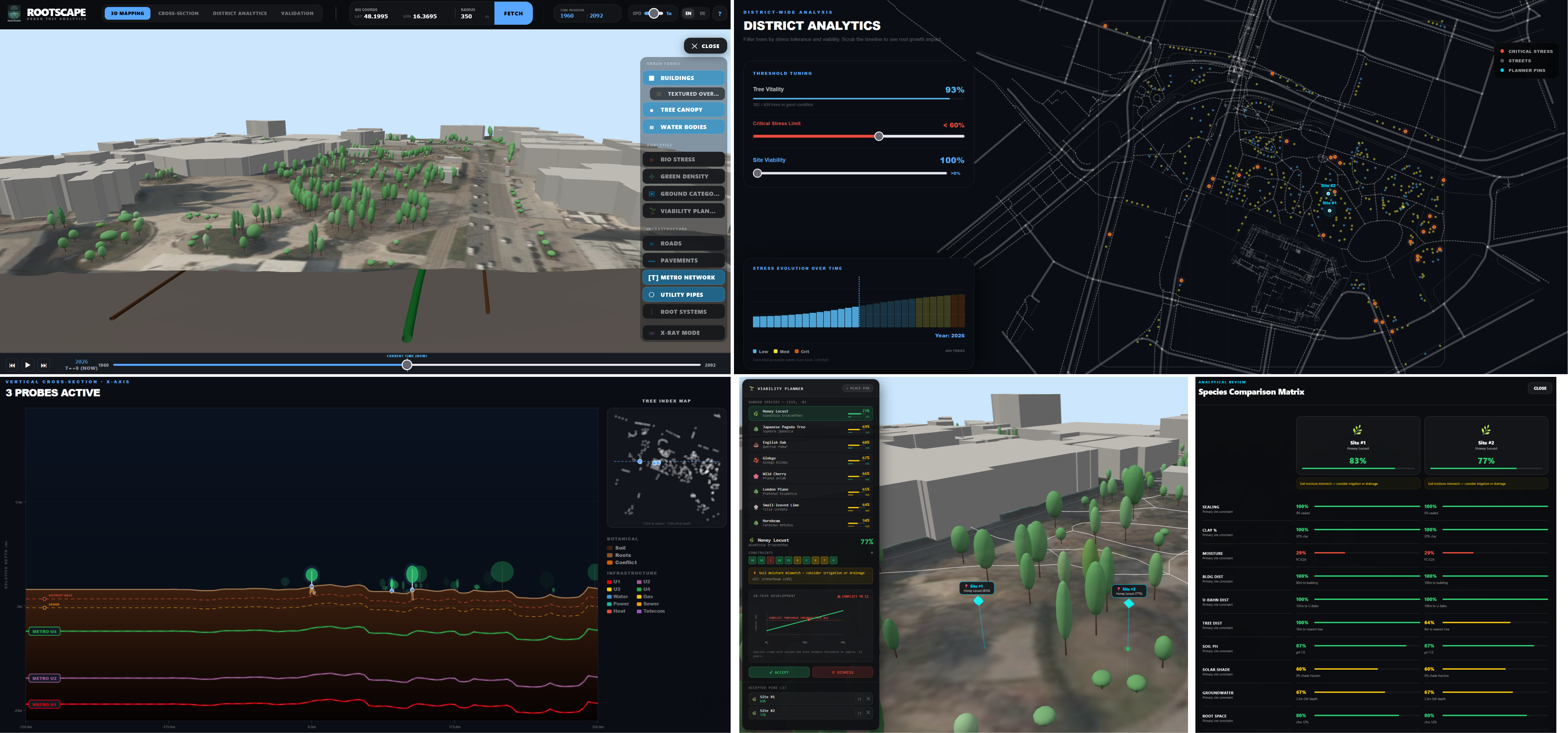
We present RootScape, a browser-based visual analytics system fusing eight open geospatial datasets for Vienna into a depth-coherent 3D scene from tree crown to tunnel. Four coordinated views support the full planning workflow: a 3D Mapping environment with user-controlled temporal simulation of root-halo and crown growth, a Cross-Section view revealing subsurface geometry at true depth, a Viability Planner scoring eight species against ten substrate constraints with per-factor breakdown and conflict-year prediction, and a District Analytics view for strategic stress assessment. Retrospective validation against the Vienna Baumkataster surfaces 81 unexplained high-stress trees in our study area as inspection candidates and produces zero false high-risk alarms. RootScape is the first system to expose the invisible subsurface conflict between urban greenery and gray infrastructure in an interactive, open-data, planning-oriented context. The codebase and demo are publicly available at https://github.com/AngelikiGram/rootscape.Additional Files and Images


Weblinks
BibTeX
@misc{grammatikaki-2026-rootscape,
  title =      "RootScape: Visual Analytics for Subsurface-Aware Urban Tree
               Planning",
  author =     "Angeliki Grammatikaki and Milena Vuckovic and Manuela
               Waldner",
  year =       "2026",
  abstract =   "We present RootScape, a browser-based visual analytics
               system fusing eight open geospatial datasets for Vienna into
               a depth-coherent 3D scene from tree crown to tunnel. Four
               coordinated views support the full planning workflow: a 3D
               Mapping environment with user-controlled temporal simulation
               of root-halo and crown growth, a Cross-Section view
               revealing subsurface geometry at true depth, a Viability
               Planner scoring eight species against ten substrate
               constraints with per-factor breakdown and conflict-year
               prediction, and a District Analytics view for strategic
               stress assessment. Retrospective validation against the
               Vienna Baumkataster surfaces 81 unexplained high-stress
               trees in our study area as inspection candidates and
               produces zero false high-risk alarms. RootScape is the first
               system to expose the invisible subsurface conflict between
               urban greenery and gray infrastructure in an interactive,
               open-data, planning-oriented context. The codebase and demo
               are publicly available at
               https://github.com/AngelikiGram/rootscape.",
  month =      apr,
  publisher =  "The Eurographics Association",
  location =   "Nottingham",
  isbn =       "978-3-03868-305-6",
  event =      "28th Eurographics Conference on Visualization (EuroVis 2026)",
  editor =     "Elshealhy, Mai and Furmanova, Katarina and Garrison, Laura
               and M\'{e}doc, Nicolas",
  doi =        "10.2312/evpd.20261025",
  booktitle =  "EuroVis 2026 : 28th Eurographics Conference on Visualization
               2026 : Posters",
  pages =      "3",
  Conference date = "Poster presented at 28th Eurographics Conference on
               Visualization (EuroVis 2026) (2026-06-08--2026-06-12)",
  keywords =   "Visual analytics, Geographic visualization, Rendering",
  URL =        "https://www.cg.tuwien.ac.at/research/publications/2026/grammatikaki-2026-rootscape/",
}