

Julia Hofmann
Visualization of Points of Interest in 3D Digital Maps
[ thesis] [GitHub]
Information
- Publication Type: Bachelor Thesis
- Workgroup(s)/Project(s):
- Date: October 2025
- Date (Start): 23. October 2024
- Date (End): 4. October 2025
- Matrikelnummer: 11827004
- First Supervisor:

Abstract
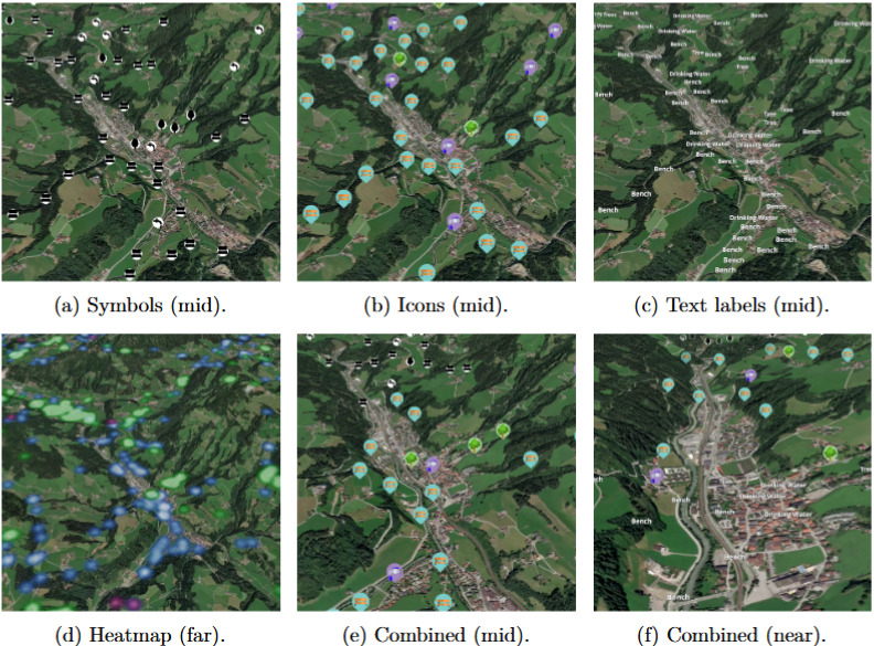
Landmarks are central to spatial orientation, yet the design of landmarks in rural environments has not been investigated so far. This thesis investigates how landmark visualization modes should be designed to support spatial exploration and landmark comprehension on rural 3D maps. A modular, web-based prototype integrates Points of Interest (PoIs) from OpenStreetMap in an asynchronous preprocessing pipeline that cleans, categorizes, and partitions data for client-side use. A quadtree-based data management approach provides dynamic level-of-detail (LoD) to regulate density and maintain legibility across scales. Within this framework, interchangeable visualization modes (text labels, abstract symbols, pictorial icons, 3D models, and heatmaps) are implemented on a 3D terrain map of Austria, complemented by category-based filtering and details-on-demand interactions. The thesis combines system design with a literature-grounded analysis to articulate the trade-offs among these modes. The resulting guidance emphasizes scale-dependent staging of encodings, control of density before the introduction of detail, and a task-and scale-sensitive balance between abstraction and realism, with semantics exposed through lightweight interaction rather than persistent annotation. The contributions are twofold: a functional technical framework that operationalizes landmark visualization for rural 3D terrain, and a structured synthesis that clarifies when and why particular visualization methods are advantageous. Evaluation proceeds theoretically rather than through user studies, and the thesis outlines implications and hypotheses for future empirical validation.Additional Files and Images

Weblinks
BibTeX
@bachelorsthesis{hofmann_julia-2025,
  title =      "Visualization of Points of Interest in 3D Digital Maps",
  author =     "Julia Hofmann",
  year =       "2025",
  abstract =   "Landmarks are central to spatial orientation, yet the design
               of landmarks in rural environments has not been investigated
               so far. This thesis investigates how landmark visualization
               modes should be designed to support spatial exploration and
               landmark comprehension on rural 3D maps. A modular,
               web-based prototype integrates Points of Interest (PoIs)
               from OpenStreetMap in an asynchronous preprocessing pipeline
               that cleans, categorizes, and partitions data for
               client-side use. A quadtree-based data management approach
               provides dynamic level-of-detail (LoD) to regulate density
               and maintain legibility across scales. Within this
               framework, interchangeable visualization modes (text labels,
               abstract symbols, pictorial icons, 3D models, and heatmaps)
               are implemented on a 3D terrain map of Austria, complemented
               by category-based filtering and details-on-demand
               interactions. The thesis combines system design with a
               literature-grounded analysis to articulate the trade-offs
               among these modes. The resulting guidance emphasizes
               scale-dependent staging of encodings, control of density
               before the introduction of detail, and a task-and
               scale-sensitive balance between abstraction and realism,
               with semantics exposed through lightweight interaction
               rather than persistent annotation. The contributions are
               twofold: a functional technical framework that
               operationalizes landmark visualization for rural 3D terrain,
               and a structured synthesis that clarifies when and why
               particular visualization methods are advantageous.
               Evaluation proceeds theoretically rather than through user
               studies, and the thesis outlines implications and hypotheses
               for future empirical validation.",
  month =      oct,
  address =    "Favoritenstrasse 9-11/E193-02, A-1040 Vienna, Austria",
  school =     "Research Unit of Computer Graphics, Institute of Visual
               Computing and Human-Centered Technology, Faculty of
               Informatics, TU Wien ",
  URL =        "https://www.cg.tuwien.ac.at/research/publications/2025/hofmann_julia-2025/",
}