

Daniel Cornel, Silvana Zechmeister, Eduard Gröller , Jürgen Waser
Watertight Incremental Heightfield Tessellation
IEEE Transactions on Visualization and Computer Graphics, PP, May 2022. [ paper]
Information
- Publication Type: Journal Paper (without talk)
- Workgroup(s)/Project(s):
- Date: May 2022
- DOI: 10.1109/TVCG.2022.3173081
- ISSN: 1941-0506
- Journal: IEEE Transactions on Visualization and Computer Graphics
- Pages: 12
- Volume: PP
- Publisher: Institute of Electrical and Electronics Engineers (IEEE)
- Keywords: Data visualization, Graphics processing units, heightfield rendering, Interpolation, level of detail, Merging, Real-time systems, Rendering (computer graphics), Surface reconstruction, terrain rendering, tessellation, Visualization techniques and methodologies
Abstract
In this paper, we propose a method for the interactive visualization of medium-scale dynamic heightfields without visual artifacts. Our data fall into a category too large to be rendered directly at full resolution, but small enough to fit into GPU memory without pre-filtering and data streaming. We present the real-world use case of unfiltered flood simulation data of such medium scale that need to be visualized in real time for scientific purposes. Our solution facilitates compute shaders to maintain a guaranteed watertight triangulation in GPU memory that approximates the interpolated heightfields with view-dependent, continuous levels of detail. In each frame, the triangulation is updated incrementally by iteratively refining the cached result of the previous frame to minimize the computational effort. In particular, we minimize the number of heightfield sampling operations to make adaptive and higher-order interpolations viable options. We impose no restriction on the number of subdivisions and the achievable level of detail to allow for extreme zoom ranges required in geospatial visualization. Our method provides a stable runtime performance and can be executed with a limited time budget. We present a comparison of our method to three state-of-the-art methods, in which our method is competitive to previous non-watertight methods in terms of runtime, while outperforming them in terms of accuracy.Additional Files and Images
Additional images and videos
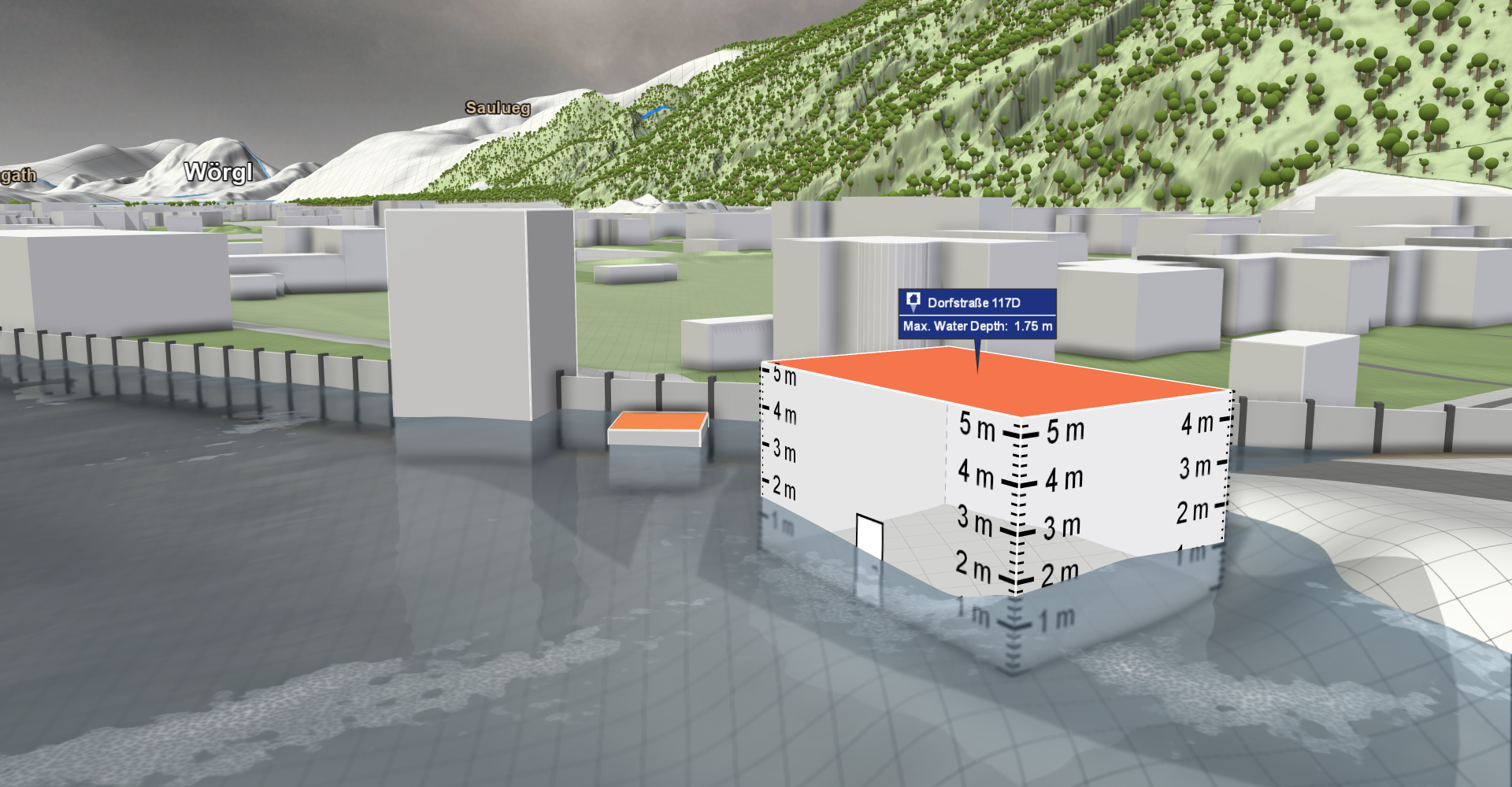
detail:
Real-time visualization result of our method for decision support in flood management. Close-up of flood simulation results at 1 m resolution.
 overview:
Real-time visualization result of our method for decision support in flood management. Overview perspective
with geospatial data of Austria. Three nested terrain heightfields defined on an area of 572 km × 293 km are combined with
a dynamic water heightfield in a focus region of 22 km × 15 km .
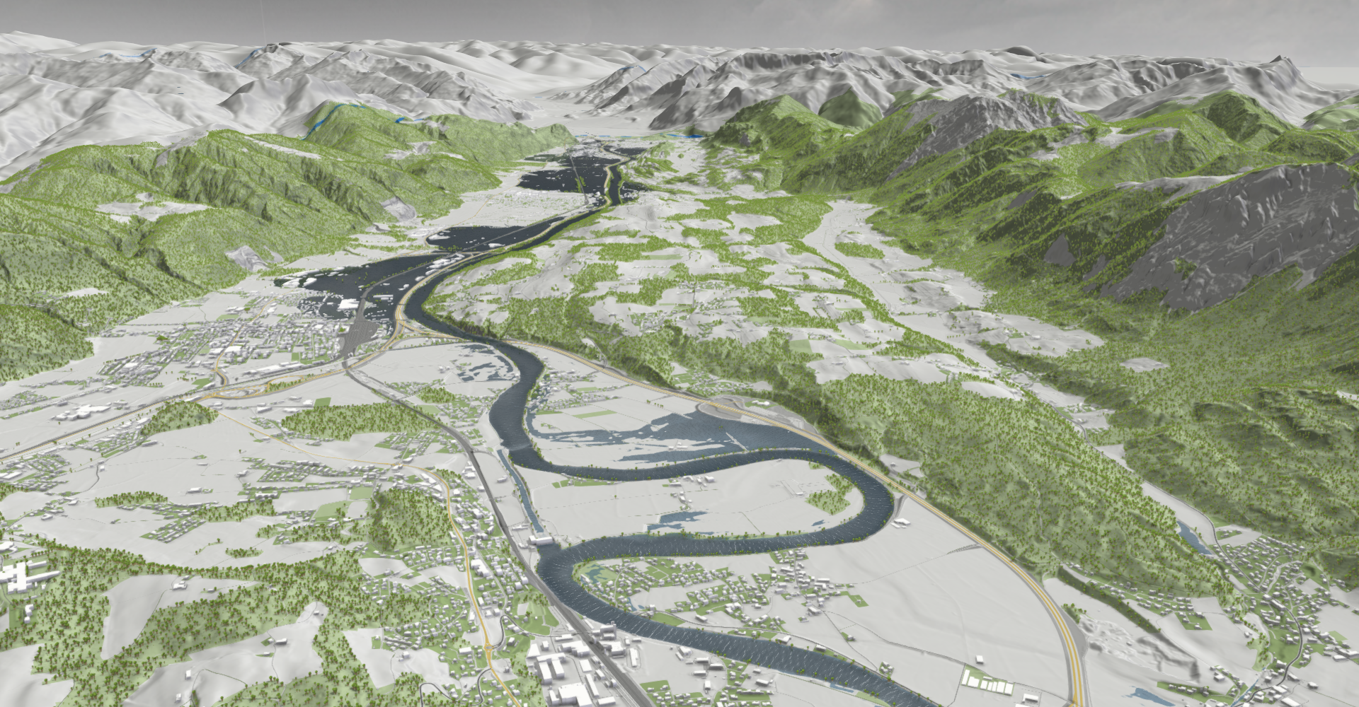
overview:
Real-time visualization result of our method for decision support in flood management. Overview perspective
with geospatial data of Austria. Three nested terrain heightfields defined on an area of 572 km × 293 km are combined with
a dynamic water heightfield in a focus region of 22 km × 15 km .
Additional files

Weblinks
BibTeX
@article{cornel-2022-wih,
  title =      "Watertight Incremental Heightfield Tessellation",
  author =     "Daniel Cornel and Silvana Zechmeister and Eduard Gr\"{o}ller
               and J\"{u}rgen Waser",
  year =       "2022",
  abstract =   "In this paper, we propose a method for the interactive
               visualization of medium-scale dynamic heightfields without
               visual artifacts. Our data fall into a category too large to
               be rendered directly at full resolution, but small enough to
               fit into GPU memory without pre-filtering and data
               streaming. We present the real-world use case of unfiltered
               flood simulation data of such medium scale that need to be
               visualized in real time for scientific purposes. Our
               solution facilitates compute shaders to maintain a
               guaranteed watertight triangulation in GPU memory that
               approximates the interpolated heightfields with
               view-dependent, continuous levels of detail. In each frame,
               the triangulation is updated incrementally by iteratively
               refining the cached result of the previous frame to minimize
               the computational effort. In particular, we minimize the
               number of heightfield sampling operations to make adaptive
               and higher-order interpolations viable options. We impose no
               restriction on the number of subdivisions and the achievable
               level of detail to allow for extreme zoom ranges required in
               geospatial visualization. Our method provides a stable
               runtime performance and can be executed with a limited time
               budget. We present a comparison of our method to three
               state-of-the-art methods, in which our method is competitive
               to previous non-watertight methods in terms of runtime,
               while outperforming them in terms of accuracy.",
  month =      may,
  doi =        "10.1109/TVCG.2022.3173081",
  issn =       "1941-0506",
  journal =    "IEEE Transactions on Visualization and Computer Graphics",
  pages =      "12",
  volume =     "PP",
  publisher =  "Institute of Electrical and Electronics Engineers (IEEE)",
  keywords =   "Data visualization, Graphics processing units, heightfield
               rendering, Interpolation, level of detail, Merging,
               Real-time systems, Rendering (computer graphics), Surface
               reconstruction, terrain rendering, tessellation,
               Visualization techniques and methodologies",
  URL =        "https://www.cg.tuwien.ac.at/research/publications/2022/cornel-2022-wih/",
}