

Tobias Batik
Embedding User-Defined Shapes into Metro Map Layouts
[ thesis]
Information
- Publication Type: Bachelor Thesis
- Workgroup(s)/Project(s): not specified
- Date: March 2021
- Date (Start): 2020
- Date (End): 2021
- Matrikelnummer: 11701221
- First Supervisor: Hsiang-Yun Wu

Abstract
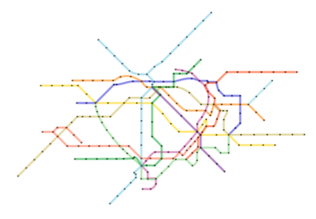
Metro maps are essential when navigating through a public transportation network. They are schematic maps that have the aim to make orientation and navigation through a metro system easier. But creating them is quite complicated. Therefore numerous algorithms have been developed in the past trying to generate these maps automatically. The downside to using this approach is, that the designer only has limited possibilities to influence the resulting layout as well as contextual information of the city can not be taken into account. In order to overcome this limitation, this thesis presents a method where a potential user could influence the resulting layout by adding a set of guide paths. This method can be used to create artistically pleasing metro maps as well as make metro lines follow symbolic shapes in the layout. A mixed-layout – where some edges are rotated to be parallel to the closest guide path and other parts are octilinear – is proposed to integrate the guide paths better into the layout. To outline the potentials of this approach, examples of several metro networks were generated and are later also discussed.Additional Files and Images

Weblinks
No further information available.BibTeX
@bachelorsthesis{Batik-2021,
  title =      "Embedding User-Defined Shapes into Metro Map Layouts",
  author =     "Tobias Batik",
  year =       "2021",
  abstract =   "Metro maps are essential when navigating through a public
               transportation network. They are schematic maps that have
               the aim to make orientation and navigation through a metro
               system easier. But creating them is quite complicated.
               Therefore numerous algorithms have been developed in the
               past trying to generate these maps automatically. The
               downside to using this approach is, that the designer only
               has limited possibilities to influence the resulting layout
               as well as contextual information of the city can not be
               taken into account. In order to overcome this limitation,
               this thesis presents a method where a potential user could
               influence the resulting layout by adding a set of guide
               paths. This method can be used to create artistically
               pleasing metro maps as well as make metro lines follow
               symbolic shapes in the layout. A mixed-layout – where some
               edges are rotated to be parallel to the closest guide path
               and other parts are octilinear – is proposed to integrate
               the guide paths better into the layout. To outline the
               potentials of this approach, examples of several metro
               networks were generated and are later also discussed.",
  month =      mar,
  address =    "Favoritenstrasse 9-11/E193-02, A-1040 Vienna, Austria",
  school =     "Research Unit of Computer Graphics, Institute of Visual
               Computing and Human-Centered Technology, Faculty of
               Informatics, TU Wien ",
  URL =        "https://www.cg.tuwien.ac.at/research/publications/2021/Batik-2021/",
}