

Hsiang-Yun Wu , Ken Maruyama, Takamasa Kawagoe, Kazuo Misue, Masatoshi Arikawa, Shigeo Takahashi
Aspect-Ratio-Preserved Labeling on Metro Maps
Poster shown at Schematic Mapping Workshop 2019
(2019)
Information
- Publication Type: Poster
- Workgroup(s)/Project(s):
- Date: April 2019
- Event: Schematic Mapping Workshop 2019
- DOI: https://www.ac.tuwien.ac.at/files/pub/smw19-paper-5.pdf
- Call for Papers: Call for Paper
- Conference date: 2019
- Keywords: Progressive Annotation, Geodesic Distances, Schematic Layout, Mental Maps, Mixed-Integer Programming
Abstract
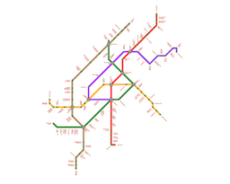
For better readability, metro lines are often aligned along the octilinear directions. Predefined layouts, however, limit the feasibility of placing station name labels. In this paper, we present a novel approach to automating the placement of station names around a schematic network while maximally respecting its original layout as the mental map. The idea behind the proposed approach is to progressively annotate stations from congested central downtown areas to sparse rural areas by intro- ducing the sum of geodesic distances over the network to identify the proper order of stations to be annotated. Our approach elongates line segments of the network without changing their directions to spare labeling space around the station. Additional constraints are introduced to restrict the aspect ratios of the region confined by the metro network for better preservation of the mental map in the original schematic layout.Additional Files and Images

Weblinks
BibTeX
@misc{wu-2019-smwp,
  title =      "Aspect-Ratio-Preserved Labeling on Metro Maps",
  author =     "Hsiang-Yun Wu and Ken Maruyama and Takamasa  Kawagoe and
               Kazuo Misue and Masatoshi  Arikawa and Shigeo Takahashi",
  year =       "2019",
  abstract =   "For better readability, metro lines are often aligned along
               the octilinear directions. Predefined layouts, however,
               limit the feasibility of placing station name labels. In
               this paper, we present a novel approach to automating the
               placement of station names around a schematic network while
               maximally respecting its original layout as the mental map.
               The idea behind the proposed approach is to progressively
               annotate stations from congested central downtown areas to
               sparse rural areas by intro- ducing the sum of geodesic
               distances over the network to identify the proper order of
               stations to be annotated. Our approach elongates line
               segments of the network without changing their directions to
               spare labeling space around the station. Additional
               constraints are introduced to restrict the aspect ratios of
               the region confined by the metro network for better
               preservation of the mental map in the original schematic
               layout.",
  month =      apr,
  event =      "Schematic Mapping Workshop 2019",
  doi =        "https://www.ac.tuwien.ac.at/files/pub/smw19-paper-5.pdf",
  Conference date = "Poster presented at Schematic Mapping Workshop 2019 (2019)",
  keywords =   "Progressive Annotation, Geodesic Distances, Schematic
               Layout, Mental Maps, Mixed-Integer Programming",
  URL =        "https://www.cg.tuwien.ac.at/research/publications/2019/wu-2019-smwp/",
}