

Patrick Mayr
Automatic Summarization of Image Datasets
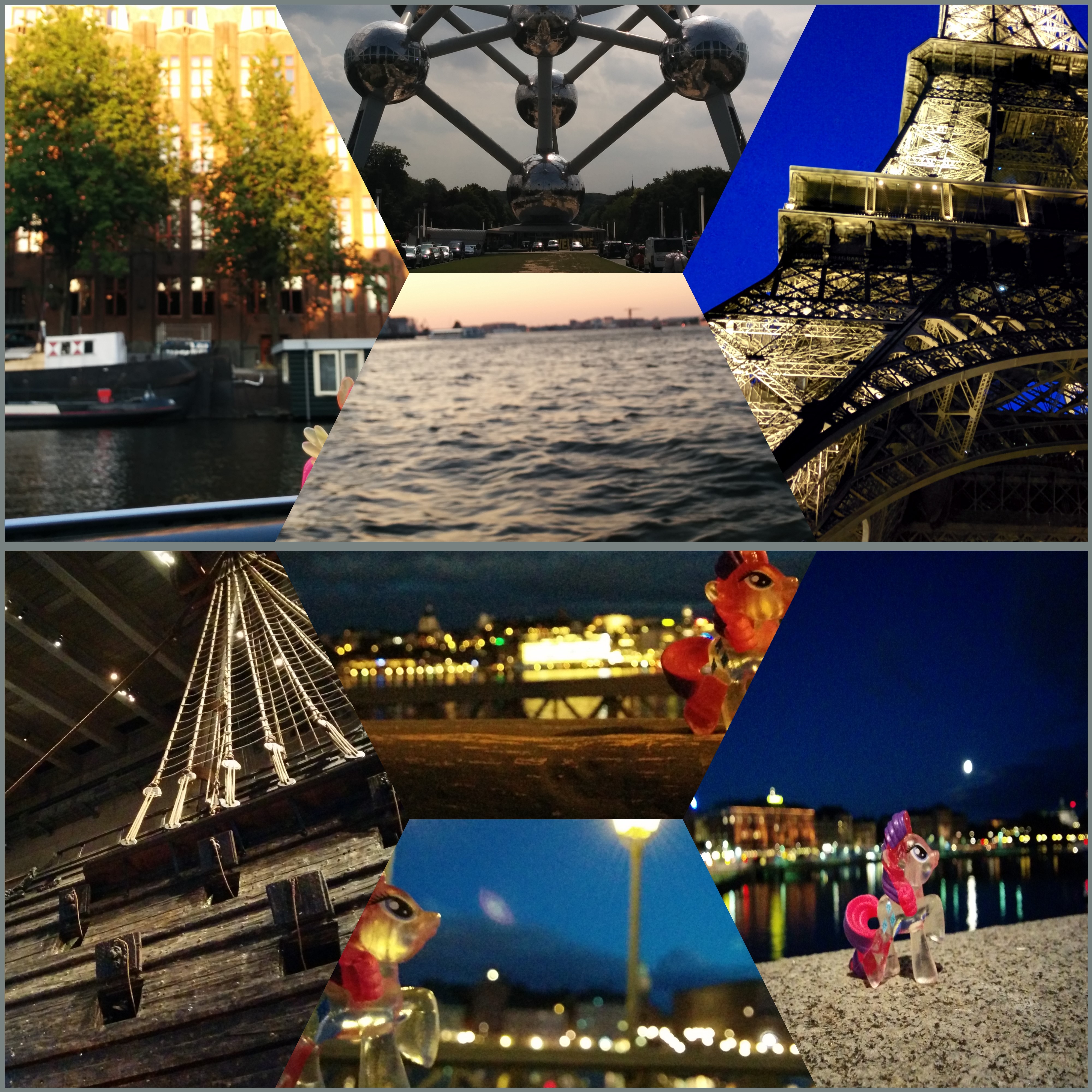
[ Bachelor Thesis] [image]
Information
- Publication Type: Bachelor Thesis
- Workgroup(s)/Project(s):
- Date: April 2017
- Date (Start): 12. October 2016
- Date (End): 20. April 2017
- Matrikelnummer: 1226745
- First Supervisor: Eduard Gröller

Abstract
Since the innovation of the digital camera the number of pictures taken is still increasing. Especially in recent years, when mobile phone manufacturer began to attach digital cameras to their mobile phones, this ended up in a flood of pictures nowadays. The aim of this thesis is, to implement an algorithm that automatically summarizes a given dataset of geotagged images and creates a representative image collage. It is strictly based on the visualization pipeline and starts with the data analysis and filtering of the image dataset. Next, the filtered data are mapped using a symmetric version of the Voronoi tessellation, and are finally rendered using optional dissolve blending. We test the implementation on two different image datasets, containing 35 and 154 images, respectively. The results indicate that the implementation generates diverse and appealing image collages for the tested image datasets, but that there are also some extreme cases for example with misleading symmetry caused by the pre-attentive processing of the human visual system.Additional Files and Images

Weblinks
No further information available.BibTeX
@bachelorsthesis{Mayr-2017-1,
  title =      "Automatic Summarization of Image Datasets",
  author =     "Patrick Mayr",
  year =       "2017",
  abstract =   "Since the innovation of the digital camera the number of
               pictures taken is still increasing. Especially in recent
               years, when mobile phone manufacturer began to attach
               digital cameras to their mobile phones, this ended up in a
               flood of pictures nowadays. The aim of this thesis is, to
               implement an algorithm that automatically summarizes a given
               dataset of geotagged images and creates a representative
               image collage. It is strictly based on the visualization
               pipeline and starts with the data analysis and filtering of
               the image dataset. Next, the filtered data are mapped using
               a symmetric version of the Voronoi tessellation, and are
               finally rendered using optional dissolve blending. We test
               the implementation on two different image datasets,
               containing 35 and 154 images, respectively. The results
               indicate that the implementation generates diverse and
               appealing image collages for the tested image datasets, but
               that there are also some extreme cases for example with
               misleading symmetry caused by the pre-attentive processing
               of the human visual system.",
  month =      apr,
  address =    "Favoritenstrasse 9-11/E193-02, A-1040 Vienna, Austria",
  school =     "Institute of Computer Graphics and Algorithms, Vienna
               University of Technology ",
  URL =        "https://www.cg.tuwien.ac.at/research/publications/2017/Mayr-2017-1/",
}