

Claus Scheiblauer, Michael Pregesbauer
Consolidated Visualization of Enormous 3D Scan Point Clouds with Scanopy
In Proceedings of the 16th International Conference on Cultural Heritage and New Technologies, pages 242-247. November 2011.
[ paper]
Information
- Publication Type: Conference Paper
- Workgroup(s)/Project(s):
- Date: November 2011
- ISBN: 978-3-200-02740-4
- Location: Vienna, Austria
- Lecturer: Claus Scheiblauer
- Booktitle: Proceedings of the 16th International Conference on Cultural Heritage and New Technologies
- Conference date: 14. November 2011 – 16. November 2011
- Pages: 242 – 247
- Keywords: point rendering, resampling, out-of-core
Abstract
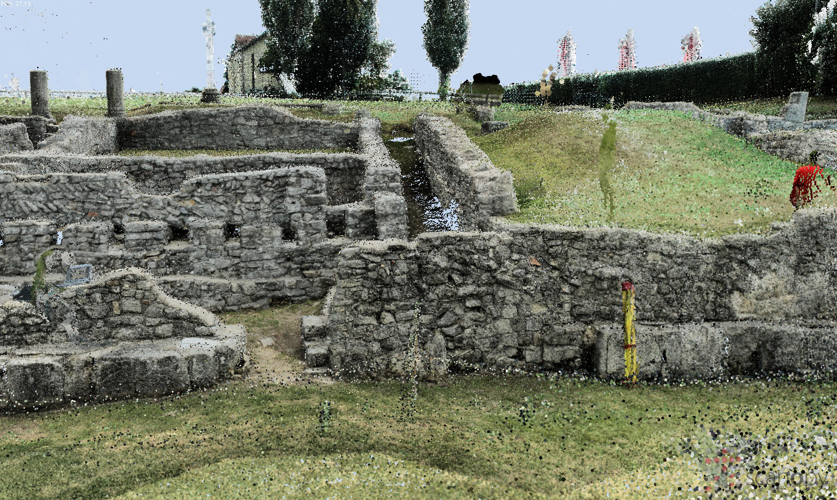
Terrestrial laser scanners are used at many excavations for documentation and inventory taking. For the documentation of the excavation Amphitheatre 1 in Bad Deutsch-Altenburg, Austria, the terrestrial laser scanner Riegl LMS Z420i was used. Overall, the entire excavation was covered by about 200 positions. With each scan position the amount of data recorded increases and this leads to performance problems in the visualization of the data. Due to the enormous number of points a consolidated representation of the entire point cloud is not possible with conventional software. The software Scanopy was developed for presenting and editing huge amounts of point data. Furthermore, it is possible to load polygonal models and display them together with point clouds in one scene. This allows an exact documentation of large archaeological excavation sites. Another application is the visualization of polygonal models of different excavation levels. The simplest visualization of point clouds on screen is a representation of the points as square rectangles. This, however, creates geometric inaccuracies, and colored point clouds are presented with sudden color changes. When the points are displayed by using semi-transparent circles the 3D points can be blended and lead to a more homogenous visual representation of the scanned objects. Thus the visual impression of the point cloud will be improved considerably. The developed software is demonstrated on the excavation mentioned above.Additional Files and Images

Weblinks
No further information available.BibTeX
@inproceedings{scheiblauer-2011-chnt,
  title =      "Consolidated Visualization of Enormous 3D Scan Point Clouds
               with Scanopy",
  author =     "Claus Scheiblauer and Michael Pregesbauer",
  year =       "2011",
  abstract =   "Terrestrial laser scanners are used at many excavations for
               documentation and inventory taking. For the documentation of
               the excavation Amphitheatre 1 in Bad Deutsch-Altenburg,
               Austria, the terrestrial laser scanner Riegl LMS Z420i was
               used. Overall, the entire excavation was covered by about
               200 positions. With each scan position the amount of data
               recorded increases and this leads to performance problems in
               the visualization of the data. Due to the enormous number of
               points a consolidated representation of the entire point
               cloud is not possible with conventional software. The
               software Scanopy was developed for presenting and editing
               huge amounts of point data. Furthermore, it is possible to
               load polygonal models and display them together with point
               clouds in one scene. This allows an exact documentation of
               large archaeological excavation sites. Another application
               is the visualization of polygonal models of different
               excavation levels. The simplest visualization of point
               clouds on screen is a representation of the points as square
               rectangles. This, however, creates geometric inaccuracies,
               and colored point clouds are presented with sudden color
               changes. When the points are displayed by using
               semi-transparent circles the 3D points can be blended and
               lead to a more homogenous visual representation of the
               scanned objects. Thus the visual impression of the point
               cloud will be improved considerably. The developed software
               is demonstrated on the excavation mentioned above.",
  month =      nov,
  isbn =       "978-3-200-02740-4",
  location =   "Vienna, Austria",
  booktitle =  "Proceedings of the 16th International Conference on Cultural
               Heritage and New Technologies",
  pages =      "242--247",
  keywords =   "point rendering, resampling, out-of-core",
  URL =        "https://www.cg.tuwien.ac.at/research/publications/2011/scheiblauer-2011-chnt/",
}