

Oscar Martinez-Rubi, Stefan Verhoeven, Maarten van Meersbergen, Markus Schütz , Peter van Oosterom, Romulo Goncalves, Theo Tijssen
Taming the beast: Free and open-source massive point cloud web visualization
In Capturing Reality Forum, pages 1-1. November 2015.
Information
- Publication Type: Conference Paper
- Workgroup(s)/Project(s):
- Date: November 2015
- Lecturer: Oscar Martinez-Rubi
- Event: Capturing Reality Forum
- Booktitle: Capturing Reality Forum
- Conference date: 2015
- Pages: 1 – 1
Abstract
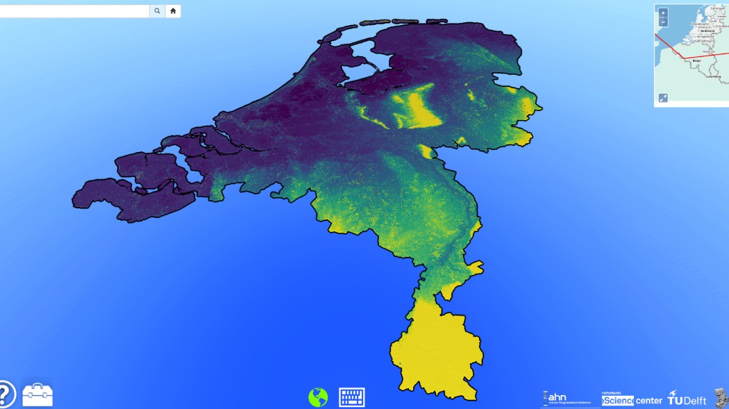
Powered by WebGL, some renderers have recently become available for the visualization of point cloud data over the web, for example Plasio or Potree. We have extended Potree to be able to visualize massive point clouds and we have successfully used it with the second national Lidar survey of the Netherlands, AHN2, with 640 billion points. In addition to the visualization, the publicly available service at ttp://ahn2.pointclouds.nl/ also features a multi-resolution download tool, a geographic name search bar, a measurement toolkit, a 2D orientation map with field of view depiction, a demo mode and the tuning of the visualization parameters. Potree relies on reorganizing the point cloud data into an multi-resolution octree data structure. However, this reorganization is very time consuming for massive data sets. Hence, we have used a divide and conquer approach to decrease the octree creation time. To achieve such performance improvement we divided the entire space into smaller cells, generated an octree for each of them in a distributed manner and then we merged them into a single massive octree. The merging is possible because the extent of all the nodes of the octrees is known and fixed. All the developed tools are free and open-source (FOSS) and they can be used to visualize over the web other massive point clouds.
Additional Files and Images

Weblinks
No further information available.BibTeX
@inproceedings{Martinez-2015-TTB,
  title =      "Taming the beast: Free and open-source massive point cloud
               web visualization",
  author =     "Oscar  Martinez-Rubi and Stefan  Verhoeven and Maarten  van
               Meersbergen and Markus Sch\"{u}tz and Peter  van Oosterom
               and Romulo Goncalves and Theo Tijssen",
  year =       "2015",
  abstract =   "Powered by WebGL, some renderers have recently become
               available for the visualization of point cloud data over the
               web, for example Plasio or Potree. We have extended Potree
               to be able to visualize massive point clouds and we have
               successfully used it with the second national Lidar survey
               of the Netherlands, AHN2, with 640 billion points. In
               addition to the visualization, the publicly available
               service at ttp://ahn2.pointclouds.nl/ also features a
               multi-resolution download tool, a geographic name search
               bar, a measurement toolkit, a 2D orientation map with field
               of view depiction, a demo mode and the tuning of the
               visualization parameters. Potree relies on reorganizing the
               point cloud data into an multi-resolution octree data
               structure. However, this reorganization is very time
               consuming for massive data sets. Hence, we have used a
               divide and conquer approach to decrease the octree creation
               time. To achieve such performance improvement we divided the
               entire space into smaller cells, generated an octree for
               each of them in a distributed manner and then we merged them
               into a single massive octree. The merging is possible
               because the extent of all the nodes of the octrees is known
               and fixed. All the developed tools are free and open-source
               (FOSS) and they can be used to visualize over the web other
               massive point clouds.  ",
  month =      nov,
  event =      "Capturing Reality Forum",
  booktitle =  "Capturing Reality Forum",
  pages =      "1--1",
  URL =        "https://www.cg.tuwien.ac.at/research/publications/2015/Martinez-2015-TTB/",
}